
~ Pepacton Reservoir NY topo map, 1:100000 scale, 30 X 60 Minute, Historical, 1986, updated 1986
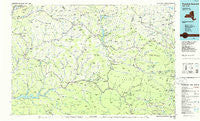
Pepacton Reservoir, New York, USGS topographic map dated 1986.
Includes geographic coordinates (latitude and longitude). This topographic map is suitable for hiking, camping, and exploring, or framing it as a wall map.
Printed on-demand using high resolution imagery, on heavy weight and acid free paper, or alternatively on a variety of synthetic materials.
Topos available on paper, Waterproof, Poly, or Tyvek. Usually shipping rolled, unless combined with other folded maps in one order.
- Product Number: USGS-5454731
- Free digital map download (high-resolution, GeoPDF): Pepacton Reservoir, New York (file size: 14 MB)
- Map Size: please refer to the dimensions of the GeoPDF map above
- Weight (paper map): ca. 55 grams
- Map Type: POD USGS Topographic Map
- Map Series: HTMC
- Map Verison: Historical
- Cell ID: 68136
- Scan ID: 136787
- Imprint Year: 1986
- Woodland Tint: Yes
- Visual Version Number: 1
- Aerial Photo Year: 1981
- Edit Year: 1986
- Datum: NAD27
- Map Projection: Universal Transverse Mercator
- Planimetric: Yes
- Map published by United States Geological Survey
- Map Language: English
- Scanner Resolution: 600 dpi
- Map Cell Name: Pepacton Reservoir
- Grid size: 30 X 60 Minute
- Date on map: 1986
- Map Scale: 1:100000
- Geographical region: New York, United States
Neighboring Maps:
All neighboring USGS topo maps are available for sale online at a variety of scales.
Spatial coverage:
Topo map Pepacton Reservoir, New York, covers the geographical area associated the following places:
- Dunraven - Vega - Broome Center - Halcottsville - Purling - Hanley Corner - Potter Hollow - Hunter - Norton Hill - Durso Corner - Hamden - Alcott Trailer Park - Clovesville - Blue Mountain - Smith Corner - Arena - Beechford - De Lancey - West Saugerties - Bates - Lexington - Greenville - Byrdcliffe - Hubbell Corners - East Durham - Centerville - Butts Corner - Mount Tremper - Woodland - Round Top - Gilboa - Fraser - Cornwallville - Cooksburg - Beaver Springs Mobile Home Park - Woodstock - Owlsville - North Kortright - West Kortright - High Woods - Lanesville - Elliot Mobile Home Park - Harpersfield - Kortright Station - Lewbeach - Flat Creek - Red Falls - Medusa - East Delhi - Cold Brook - Mosquito Point - Shackport - Pindars Corners - West Conesville - Manorville - Phoenicia - West Kill - West Greenville - North Blenheim - West Davenport - Meredith - Lake Hill - Colliersville - Cooperstown Junction - Chichester - Wittenberg - Grant Mills - Davenport Center - Shady - Ledgewood Park - North Settlement - Halcott Center - South Gilboa - Freehold - Shandaken - Lake Delaware - Delhi - Onteora Park - Big Indian - South Durham - Greenville Center - Acra - Hobart - Grand Gorge - Ruby - West Jewett - Andes - Jewett - South Westerlo - West Settlement - Hoseaville - Palenville - Longyear (historical) - West Harpersfield - Oliverea - Platte Clove - Edgewood - Grand Gorge - Fish Creek - Davenport
- Map Area ID: AREA42.542-75-74
- Northwest corner Lat/Long code: USGSNW42.5-75
- Northeast corner Lat/Long code: USGSNE42.5-74
- Southwest corner Lat/Long code: USGSSW42-75
- Southeast corner Lat/Long code: USGSSE42-74
- Northern map edge Latitude: 42.5
- Southern map edge Latitude: 42
- Western map edge Longitude: -75
- Eastern map edge Longitude: -74


