
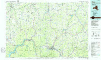
~ Olean NY topo map, 1:100000 scale, 30 X 60 Minute, Historical, 1986, updated 1986
Olean, New York, USGS topographic map dated 1986.
Includes geographic coordinates (latitude and longitude). This topographic map is suitable for hiking, camping, and exploring, or framing it as a wall map.
Printed on-demand using high resolution imagery, on heavy weight and acid free paper, or alternatively on a variety of synthetic materials.
Topos available on paper, Waterproof, Poly, or Tyvek. Usually shipping rolled, unless combined with other folded maps in one order.
- Product Number: USGS-5454727
- Free digital map download (high-resolution, GeoPDF): Olean, New York (file size: 15 MB)
- Map Size: please refer to the dimensions of the GeoPDF map above
- Weight (paper map): ca. 55 grams
- Map Type: POD USGS Topographic Map
- Map Series: HTMC
- Map Verison: Historical
- Cell ID: 68088
- Scan ID: 137482
- Imprint Year: 1986
- Woodland Tint: Yes
- Visual Version Number: 1
- Aerial Photo Year: 1981
- Edit Year: 1986
- Datum: NAD27
- Map Projection: Universal Transverse Mercator
- Planimetric: Yes
- Map published by United States Geological Survey
- Map Language: English
- Scanner Resolution: 600 dpi
- Map Cell Name: Olean
- Grid size: 30 X 60 Minute
- Date on map: 1986
- Map Scale: 1:100000
- Geographical region: New York, United States
Neighboring Maps:
All neighboring USGS topo maps are available for sale online at a variety of scales.
Spatial coverage:
Topo map Olean, New York, covers the geographical area associated the following places:
- Fillmore - Olean - Belfast - Higgins - Sanford - Short Tract - Barbers Trailer Ranch - Portville - Machias - Randolph - Sawyer - Gowanda - Mill Grove - Underwood Corner - Main Settlement - Maplehurst - Nile - Centerville - Freedom Mobile Home Park - Lyndon - Ashford - East Olean - Rawson - Sawyer Trailer Court - Franklinville - Lake View Terrace - Rossburg - Haydenville - Eddyville - Baldwin Heights - Weston Mills - Kossuth - Inavale - Steamburg - West Notch - Maples - Vosburg - Fox - Napoli - Shongo - Abbotts - Allegany - Rock City - Riceville - East Otto - Colonial Village Mobile Home Park - Bowler - Lyons Corners - Marshall - Lime Lake - Nichols Run - Village of Saint Anthony - Carroll - South Olean - Harrisburg - Valley View Estates Mobile Home Park - Collins Center - Houghton - Belvidere - Maple Grove Mobile Home Estates - Germantown - Belmont - Rockville - Obi - Cadiz - Elton - Hume - Willoughby - Barnum - Little Valley - Homer Hill - Machias Junction - Allentown - Bolivar - Dayton - Pikeville - Knapp Creek - Humphrey Center - Elkdale - Sugartown - Bird - Cuba - Cold Spring - Boardmanville - Knight Creek - Petrolia - Red House - Snyders Corners - Little Rock City - Seneca Heights - Otto - Hillcrest - Persia - Great Valley - Angelica - Alma - Richburg - South Cuba - Hardy Corners - North Cuba
- Map Area ID: AREA42.542-79-78
- Northwest corner Lat/Long code: USGSNW42.5-79
- Northeast corner Lat/Long code: USGSNE42.5-78
- Southwest corner Lat/Long code: USGSSW42-79
- Southeast corner Lat/Long code: USGSSE42-78
- Northern map edge Latitude: 42.5
- Southern map edge Latitude: 42
- Western map edge Longitude: -79
- Eastern map edge Longitude: -78


