
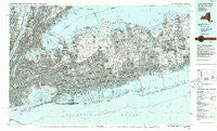
~ Long Island West NY topo map, 1:100000 scale, 30 X 60 Minute, Historical, 1984, updated 1986
Long Island West, New York, USGS topographic map dated 1984.
Includes geographic coordinates (latitude and longitude). This topographic map is suitable for hiking, camping, and exploring, or framing it as a wall map.
Printed on-demand using high resolution imagery, on heavy weight and acid free paper, or alternatively on a variety of synthetic materials.
Topos available on paper, Waterproof, Poly, or Tyvek. Usually shipping rolled, unless combined with other folded maps in one order.
- Product Number: USGS-5454699
- Free digital map download (high-resolution, GeoPDF): Long Island West, New York (file size: 30 MB)
- Map Size: please refer to the dimensions of the GeoPDF map above
- Weight (paper map): ca. 55 grams
- Map Type: POD USGS Topographic Map
- Map Series: HTMC
- Map Verison: Historical
- Cell ID: 67869
- Scan ID: 137378
- Imprint Year: 1986
- Visual Version Number: 1
- Aerial Photo Year: 1983
- Edit Year: 1984
- Datum: NAD27
- Map Projection: Universal Transverse Mercator
- Planimetric: Yes
- Map published by United States Geological Survey
- Map Language: English
- Scanner Resolution: 600 dpi
- Map Cell Name: Long Island West
- Grid size: 30 X 60 Minute
- Date on map: 1984
- Map Scale: 1:100000
- Geographical region: New York, United States
Neighboring Maps:
All neighboring USGS topo maps are available for sale online at a variety of scales.
Spatial coverage:
Topo map Long Island West, New York, covers the geographical area associated the following places:
- Bronxdale - Lonelyville - Tremont - Flatiron District - Unionport - Centre Island - Woodbury - Manhattan Beach - Gashouse District - Keshaechquereren (historical) - Lakeland - Crestwood - Amity Harbor - Park Slope - Oceanside - James Weldon Johnson Houses - West Farms - Cedarhurst - Hewlett Harbor - Glen Oaks - Gunther Park - Valley Stream - Residence Park - East Northport - Old Brookville - Sumner Houses - Concourse Village - North Wantagh - Forest Hills Gardens - Melrose - Saltaire - Alden Manor - Farmingville - Plaza Borinquen - Bellerose - Wincoma - Greenville - Spuyten Duyvil - Cherry Grove - Brooklyn - Inwood - East Williston - Lattingtown - Linden Hill - Harbor Green - Kips Bay - Morrisania - Gowanus Houses - Long Island City - Victory Park - Lloyd Harbor - Rye - Riverdale - North Hills - Blissville - Murray Hill - Tompkins Houses - Albertson - Paerdegat - Rochelle Park - Mill Neck - Moorelands - Lower Melville - Closter - Bergenfield - Fordham Hill - Jackson Houses - West Amityville - Hamilton Beach - Leonia - Fort Lee - Syosset - Tudor City - Fenmore Park - John Adams Houses - McLean Heights - Head of the Harbor - Eastern Parkway - Laurelton - Lido Beach - Charlotteville (historical) - Hillside Manor - Woodside - Adelphi - Patterson Houses - Centereach - Spring Creek Towers - Bethpage - Lake Grove - Kew Gardens Hills - Seaside - Colonial Heights - Palisades Park - Park West Village - Manhasset - East Massapequa - Dodgewood - Forest Heights - Cold Spring Harbor - Hammel
- Map Area ID: AREA4140.5-74-73
- Northwest corner Lat/Long code: USGSNW41-74
- Northeast corner Lat/Long code: USGSNE41-73
- Southwest corner Lat/Long code: USGSSW40.5-74
- Southeast corner Lat/Long code: USGSSE40.5-73
- Northern map edge Latitude: 41
- Southern map edge Latitude: 40.5
- Western map edge Longitude: -74
- Eastern map edge Longitude: -73


