
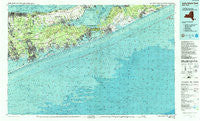
~ Long Island East NY topo map, 1:100000 scale, 30 X 60 Minute, Historical, 1984, updated 1988
Long Island East, New York, USGS topographic map dated 1984.
Includes geographic coordinates (latitude and longitude). This topographic map is suitable for hiking, camping, and exploring, or framing it as a wall map.
Printed on-demand using high resolution imagery, on heavy weight and acid free paper, or alternatively on a variety of synthetic materials.
Topos available on paper, Waterproof, Poly, or Tyvek. Usually shipping rolled, unless combined with other folded maps in one order.
- Product Number: USGS-5454693
- Free digital map download (high-resolution, GeoPDF): Long Island East, New York (file size: 34 MB)
- Map Size: please refer to the dimensions of the GeoPDF map above
- Weight (paper map): ca. 55 grams
- Map Type: POD USGS Topographic Map
- Map Series: HTMC
- Map Verison: Historical
- Cell ID: 67868
- Scan ID: 137374
- Imprint Year: 1988
- Woodland Tint: Yes
- Visual Version Number: 1
- Aerial Photo Year: 1980
- Edit Year: 1984
- Datum: NAD27
- Map Projection: Universal Transverse Mercator
- Map published by United States Geological Survey
- Map Language: English
- Scanner Resolution: 600 dpi
- Map Cell Name: Long Island East
- Grid size: 30 X 60 Minute
- Date on map: 1984
- Map Scale: 1:100000
- Geographical region: New York, United States
Neighboring Maps:
All neighboring USGS topo maps are available for sale online at a variety of scales.
Spatial coverage:
Topo map Long Island East, New York, covers the geographical area associated the following places:
- Brookhaven - Pine Neck - East Moriches - Manorville - Divinity Hill - Water Mill - Hampton Bays Mobile Home Park - Shoreham - Upton - Riverhead - Flying Point - West Hampton Dunes - East Quogue - North Bellport - Centerville - North Sea - Pantigo - Quogue - Glenwood Village - South Jamesport - East Hampton - West Mecox Village - Flanders - Devon - Noyack - Gordon Heights - Art Village - Sound Beach - Wainscott - Squiretown - Mastic Beach - New Suffolk - Springville - Siegfield Park - Eastport - Center Moriches - Apaquogue - Northville - Parkview Community - Hardscrabble - Hampton Bays - South Manor - Calverton - Ponquogue - Sagaponack - Reeves Park - Remsenburg - Hagerman - South Haven - Woodcliff Park - Speonk - Suffolk Pines - Northampton - East Quogue Mobile Home Park - Tiana - Pine Valley - Hampton Park - Sweyze - Jamesport - Old Mastic - Mastic - Hampton Beach - Bellview Beach - Laurel - Barnes Hole - Georgica - Sag Harbor - Mecox - Shinnecock Hills - Amagansett - Riverhaven Park - Foxwood Village - Mattituck - Canoe Place - Quiogue - Baiting Hollow - Oakland Ridge Mobile Home Park - Westhampton Beach - West Amagansett - Red Creek - Bayberry Dunes - Wildwood - Cobb - Ramblewood Mobile Home Park - Southampton - Pine Neck - Midhampton - Lakewood Park - East Patchogue - Wading River - Freetown - Hayground - Beach Hampton - Greenwood Village - Redwood - Thurms Mobile Homes - Rose Grove - Newtown - Rocky Point - Tuckahoe
- Map Area ID: AREA4140.5-73-72
- Northwest corner Lat/Long code: USGSNW41-73
- Northeast corner Lat/Long code: USGSNE41-72
- Southwest corner Lat/Long code: USGSSW40.5-73
- Southeast corner Lat/Long code: USGSSE40.5-72
- Northern map edge Latitude: 41
- Southern map edge Latitude: 40.5
- Western map edge Longitude: -73
- Eastern map edge Longitude: -72


