
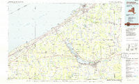
~ Jamestown NY topo map, 1:100000 scale, 30 X 60 Minute, Historical, 1986, updated 1986
Jamestown, New York, USGS topographic map dated 1986.
Includes geographic coordinates (latitude and longitude). This topographic map is suitable for hiking, camping, and exploring, or framing it as a wall map.
Printed on-demand using high resolution imagery, on heavy weight and acid free paper, or alternatively on a variety of synthetic materials.
Topos available on paper, Waterproof, Poly, or Tyvek. Usually shipping rolled, unless combined with other folded maps in one order.
- Product Number: USGS-5454677
- Free digital map download (high-resolution, GeoPDF): Jamestown, New York (file size: 16 MB)
- Map Size: please refer to the dimensions of the GeoPDF map above
- Weight (paper map): ca. 55 grams
- Map Type: POD USGS Topographic Map
- Map Series: HTMC
- Map Verison: Historical
- Cell ID: 67730
- Scan ID: 137283
- Imprint Year: 1986
- Woodland Tint: Yes
- Visual Version Number: 1
- Aerial Photo Year: 1981
- Edit Year: 1986
- Datum: NAD27
- Map Projection: Universal Transverse Mercator
- Planimetric: Yes
- Map published by United States Geological Survey
- Map Language: English
- Scanner Resolution: 600 dpi
- Map Cell Name: Jamestown
- Grid size: 30 X 60 Minute
- Date on map: 1986
- Map Scale: 1:100000
- Geographical region: New York, United States
Neighboring Maps:
All neighboring USGS topo maps are available for sale online at a variety of scales.
Spatial coverage:
Topo map Jamestown, New York, covers the geographical area associated the following places:
- Balcom - Kerrs Corners - Hornby - Connelly Park - Conewango - Vukote - Hartfield - Wango - Dean - Thornton - Loomises - Bates - Harborcreek - Pope - Burnhams - Willow Brook - Elm Tree - Skunks Corner - Hammett - Point Stockholm - Mayville - Victoria - Frewsburg - Kennedy - Maple Point - South Stockton - Lily Dale - Shumla - Sunnyside - Kimball Stand - Forsyth - Fredonia - Cottage - Bayview - Findley Lake - Shore Haven - Cordova - Sampson - Rays Corners - East Ripley - Stebbins Corners - Hadley Bay - West Greene - Sheridan - Cottage Park - Summerdale - Monticello Mobile Home Park - Volusia - Elmhurst - Clear Creek - Dodge - Maple Springs - Cook Corners - Ross Mills - Colts Station - Jamestown - Little Hope - Mina - Orchard Beach - Watts Flats - Prendergast Point - North East Junction - Arkwright - French Creek - Shore Acres - Delhill Corners - Parcells Corners - Weeds Corners - Chedwel - Orchard Terrace - Driftwood - Kabob - Sheldon Hall - Balcom Corners - Ellington - Panama - Moorheadville - Wahmeda - Crestview Estates - Phillips Mills - Griffiths - Redbird - Leon - Moorhead - Magnolia - McCenithans Mobile Home Park - Black Corners - Dunkirk - Hubbards Park - Pleasantville - Poland Center - Clymer Center - Bemus Point - Perrysburg - Colburns - Niobe - Reed Corners - North East - Charlotte Center - West Portland
- Map Area ID: AREA42.542-80-79
- Northwest corner Lat/Long code: USGSNW42.5-80
- Northeast corner Lat/Long code: USGSNE42.5-79
- Southwest corner Lat/Long code: USGSSW42-80
- Southeast corner Lat/Long code: USGSSE42-79
- Northern map edge Latitude: 42.5
- Southern map edge Latitude: 42
- Western map edge Longitude: -80
- Eastern map edge Longitude: -79


