
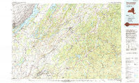
~ Gouverneur NY topo map, 1:100000 scale, 30 X 60 Minute, Historical, 1985, updated 1993
Gouverneur, New York, USGS topographic map dated 1985.
Includes geographic coordinates (latitude and longitude). This topographic map is suitable for hiking, camping, and exploring, or framing it as a wall map.
Printed on-demand using high resolution imagery, on heavy weight and acid free paper, or alternatively on a variety of synthetic materials.
Topos available on paper, Waterproof, Poly, or Tyvek. Usually shipping rolled, unless combined with other folded maps in one order.
- Product Number: USGS-5454671
- Free digital map download (high-resolution, GeoPDF): Gouverneur, New York (file size: 23 MB)
- Map Size: please refer to the dimensions of the GeoPDF map above
- Weight (paper map): ca. 55 grams
- Map Type: POD USGS Topographic Map
- Map Series: HTMC
- Map Verison: Historical
- Cell ID: 67589
- Scan ID: 137230
- Imprint Year: 1993
- Woodland Tint: Yes
- Aerial Photo Year: 1980
- Edit Year: 1985
- Datum: NAD27
- Map Projection: Universal Transverse Mercator
- Map published by United States Geological Survey
- Map Language: English
- Scanner Resolution: 600 dpi
- Map Cell Name: Gouverneur
- Grid size: 30 X 60 Minute
- Date on map: 1985
- Map Scale: 1:100000
- Geographical region: New York, United States
Neighboring Maps:
All neighboring USGS topo maps are available for sale online at a variety of scales.
Spatial coverage:
Topo map Gouverneur, New York, covers the geographical area associated the following places:
- Noseville - Great Bend - Sterlingville - Fullerville - Kimball Mill - Point Vivian - Remington Corners - Kents Corners - Shady Acres Mobile Home Park - Schermerhorn Landing - Bean Hill Crossing - Fargo - Reedville - Karter - Plessis - South Hammond - Little Bow - North Gouverneur - North Croghan - North Croghan Crossing - Gouvernor Gardens Mobile Home Park - Edwards - South Edwards - Halls Corner - Russell - Jerden Falls - South Russell - Philadelphia - Cowan Corner - Leray Trailer Park - Benson Mines - Rivergate - Stellaville - Balmat - Pikes Corner - Diana Center - Pond Settlement - Edgewood Park - Stalbird - Rossie - Emeryville - Bartletts Corner - Stone Mills - Jayville - North Wilna - Hailesboro - Godfreys Corner - Hammond - Talcville - La Fargeville - Bigelow - Backus - Evans Mills - Herrings - Black Lake (historical) - De Kalb - Indian River Estates Mobile Home Park - Chippewa Bay - Woods Mill - Clare - North Hammond - Lower Oswegatchie - Harrisville - Fine - Pinehurst Resort - West Fowler - Antwerp - Stroughs Crossing - East De Kalb - Kalurah - Westminster Park - Lake Bonaparte - Summit Trailer Park - Douglas Crossing - Natural Dam - Sanfords Four Corners - Browns Corners - Bishas Mill - Spragueville - Richville - Collins Landing - Ruby Corner - Star Lake - Degrasse - Swan Bay Estates Mobile Home Park - Oakvale - Bentleys Corners - Hermon - Jolly K Mobile Home Park - Deferiet - Fordhams Corners - Northwoods Estates Mobile Home Park - Doolins Crossing - Black River - Ridgedale Mobile Home Park - Gouverneur - Natural Bridge - Keenes - Brownville - Alexandria Bay
- Map Area ID: AREA44.544-76-75
- Northwest corner Lat/Long code: USGSNW44.5-76
- Northeast corner Lat/Long code: USGSNE44.5-75
- Southwest corner Lat/Long code: USGSSW44-76
- Southeast corner Lat/Long code: USGSSE44-75
- Northern map edge Latitude: 44.5
- Southern map edge Latitude: 44
- Western map edge Longitude: -76
- Eastern map edge Longitude: -75


