
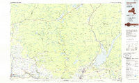
~ Gloversville NY topo map, 1:100000 scale, 30 X 60 Minute, Historical, 1985, updated 1986
Gloversville, New York, USGS topographic map dated 1985.
Includes geographic coordinates (latitude and longitude). This topographic map is suitable for hiking, camping, and exploring, or framing it as a wall map.
Printed on-demand using high resolution imagery, on heavy weight and acid free paper, or alternatively on a variety of synthetic materials.
Topos available on paper, Waterproof, Poly, or Tyvek. Usually shipping rolled, unless combined with other folded maps in one order.
- Product Number: USGS-5454667
- Free digital map download (high-resolution, GeoPDF): Gloversville, New York (file size: 14 MB)
- Map Size: please refer to the dimensions of the GeoPDF map above
- Weight (paper map): ca. 55 grams
- Map Type: POD USGS Topographic Map
- Map Series: HTMC
- Map Verison: Historical
- Cell ID: 67581
- Scan ID: 137225
- Imprint Year: 1986
- Woodland Tint: Yes
- Visual Version Number: 1
- Aerial Photo Year: 1980
- Edit Year: 1985
- Datum: NAD27
- Map Projection: Universal Transverse Mercator
- Planimetric: Yes
- Map published by United States Geological Survey
- Map Language: English
- Scanner Resolution: 600 dpi
- Map Cell Name: Gloversville
- Grid size: 30 X 60 Minute
- Date on map: 1985
- Map Scale: 1:100000
- Geographical region: New York, United States
Neighboring Maps:
All neighboring USGS topo maps are available for sale online at a variety of scales.
Spatial coverage:
Topo map Gloversville, New York, covers the geographical area associated the following places:
- Mayfield - Progress - Irondale - Herkimer - Speculator - Canada Lake - Berkshire - Norway - Emmonsburg - Arietta - Pine Lake Mobile Home Park - Middle Sprite - Green Corners - West Galway - Edinburg - Fayville - Cranberry Creek - Blackbridge - Indian Village Mobile Home Park - Whiteside Corners - Dennies Crossing - East Herkimer - Maple Grove - Old City - Lake Pleasant - North Broadalbin - Middleville - Bakertown - Sunset View Mobile Home Park - Hope - Rockwood - East Creek - Pumpkin Hollow - Gorthey Corners - Red Bunch Corners - Gray - Heyday Mobile Home Park - Vail Mills - Rolling Ridge Mobile Home Park - Curtis - Jacksonburg - Peters Corners - Nobleboro - Steele Corners - Dolgeville - Honeywell Corners - Kimball Corners - North Galway - Paper Mill Corners - Glenwild - Benson - Gloversville - Bleecker - Batchellerville - Oppenheim - Deer Creek Mobile Home Park - Fish House - Riceville - Parkis Mills - Newkirk - Union Mills - Ives Hollow - Perth - Little Falls - Lotville - Indian Castle - Ohio - Garoga - Bliss Corner - Upper Benson - Stairs Corners - Red Carpet Mobile Home Park - Fullers - Jackson Summit - Crum Creek - Fairweather Corners - Knowelhurst - Bull Hill - Eppie Corners - Kringsbush - West Day - Bleecker Center - Tenantville - Kingsboro - Lindsley Corners - Bradtville - Northville - Powley Place - Salisbury - Benedict - Sweets Crossing - Broadalbin Junction - Caroga Lake - Dempster Corners - Doxtater Corner - Meco - Ingham Mills - Lake View - Hoeseville - Stewart Landing
- Map Area ID: AREA43.543-75-74
- Northwest corner Lat/Long code: USGSNW43.5-75
- Northeast corner Lat/Long code: USGSNE43.5-74
- Southwest corner Lat/Long code: USGSSW43-75
- Southeast corner Lat/Long code: USGSSE43-74
- Northern map edge Latitude: 43.5
- Southern map edge Latitude: 43
- Western map edge Longitude: -75
- Eastern map edge Longitude: -74


