
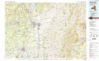
~ Glens Falls NY topo map, 1:100000 scale, 30 X 60 Minute, Historical, 1986, updated 1989
Glens Falls, New York, USGS topographic map dated 1986.
Includes geographic coordinates (latitude and longitude). This topographic map is suitable for hiking, camping, and exploring, or framing it as a wall map.
Printed on-demand using high resolution imagery, on heavy weight and acid free paper, or alternatively on a variety of synthetic materials.
Topos available on paper, Waterproof, Poly, or Tyvek. Usually shipping rolled, unless combined with other folded maps in one order.
- Product Number: USGS-5454665
- Free digital map download (high-resolution, GeoPDF): Glens Falls, New York (file size: 23 MB)
- Map Size: please refer to the dimensions of the GeoPDF map above
- Weight (paper map): ca. 55 grams
- Map Type: POD USGS Topographic Map
- Map Series: HTMC
- Map Verison: Historical
- Cell ID: 67578
- Scan ID: 137224
- Imprint Year: 1989
- Woodland Tint: Yes
- Visual Version Number: 1
- Aerial Photo Year: 1986
- Edit Year: 1989
- Datum: NAD27
- Map Projection: Universal Transverse Mercator
- Map published by United States Geological Survey
- Map Language: English
- Scanner Resolution: 600 dpi
- Map Cell Name: Glens Falls
- Grid size: 30 X 60 Minute
- Date on map: 1986
- Map Scale: 1:100000
- Geographical region: New York, United States
Neighboring Maps:
All neighboring USGS topo maps are available for sale online at a variety of scales.
Spatial coverage:
Topo map Glens Falls, New York, covers the geographical area associated the following places:
- Cossayuna - Stony Creek - The Plains - Coila - Mount Pleasant - Birch Run - Pattens Mills - Battenville - Tripoli - Brayton - Sunderland - Wilton - Thomson - Fox Run Estates - Shushan - Milton - Frink Corner - Louden Meadows - Sherwood Forest - East Arlington - Malta Ridge - Geyser Crest - West Granville - Goose Island - Fayville - Sky Ranch - Queensbury Village Mobile Home Park - Hidden Acres Mobile Court - Ashfords Way - Salem - Center Falls - South Corinth - South Dorset - Homestead Village Mobile Home Park - Ketchums Corners - Geyser Gates - Spraguetown - Fortsville - Clarks Mills - Glastenbury - Regatta View - Trotterview Trailer Park - Lake Desolation - Richville - South Greenfield - Scidmore Woods - Evergreen Trailer Park - Middle Granville - MacIntyre - Antone Mountain Mobile Home Park - Gregory Manor - White Birch Estates - Interlaken - Travers Corners - Pine Valley - Deer Run - Knoll Spring Park - Iron Furnace - West Corners - West Glens Falls - North Greenfield - South Argyle - Pruyn Crest - Strawberry Acres - Greenfield - Conklingville - Lake Vanare - North Pawlet - Victoria Gardens - Hickory Forest - West Tinmouth - Archdale - Whispering Pines Mobile Home Park - Raceville - Carlyle Estates - Lake George - Fly Summit - Woodland Court - Vaughns Corners - Slateville - East Ridge - Gansevoort - Granville - Wells - North Rupert - East Hartford - North Cambridge - North Milton - North Hebron - Porter Corners - Gates - Cleverdale - Dix Mobile Home Park - Snake Hill - Hidden Valley - Brookview - Mountain View Estates - Paradise Beach - Woodlands - Anaquassacook
- Map Area ID: AREA43.543-74-73
- Northwest corner Lat/Long code: USGSNW43.5-74
- Northeast corner Lat/Long code: USGSNE43.5-73
- Southwest corner Lat/Long code: USGSSW43-74
- Southeast corner Lat/Long code: USGSSE43-73
- Northern map edge Latitude: 43.5
- Southern map edge Latitude: 43
- Western map edge Longitude: -74
- Eastern map edge Longitude: -73


