
~ Glens Falls NY topo map, 1:100000 scale, 30 X 60 Minute, Historical, 1989, updated 1989
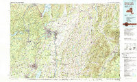
Glens Falls, New York, USGS topographic map dated 1989.
Includes geographic coordinates (latitude and longitude). This topographic map is suitable for hiking, camping, and exploring, or framing it as a wall map.
Printed on-demand using high resolution imagery, on heavy weight and acid free paper, or alternatively on a variety of synthetic materials.
Topos available on paper, Waterproof, Poly, or Tyvek. Usually shipping rolled, unless combined with other folded maps in one order.
- Product Number: USGS-5454663
- Free digital map download (high-resolution, GeoPDF): Glens Falls, New York (file size: 24 MB)
- Map Size: please refer to the dimensions of the GeoPDF map above
- Weight (paper map): ca. 55 grams
- Map Type: POD USGS Topographic Map
- Map Series: HTMC
- Map Verison: Historical
- Cell ID: 67578
- Scan ID: 137223
- Imprint Year: 1989
- Woodland Tint: Yes
- Visual Version Number: 2
- Aerial Photo Year: 1986
- Edit Year: 1989
- Datum: NAD27
- Map Projection: Universal Transverse Mercator
- Map published by United States Geological Survey
- Map Language: English
- Scanner Resolution: 600 dpi
- Map Cell Name: Glens Falls
- Grid size: 30 X 60 Minute
- Date on map: 1989
- Map Scale: 1:100000
- Geographical region: New York, United States
Neighboring Maps:
All neighboring USGS topo maps are available for sale online at a variety of scales.
Spatial coverage:
Topo map Glens Falls, New York, covers the geographical area associated the following places:
- Evergreen Trailer Park - Slateville - Castlewood - West Fort Ann - Brookview Village Mobile Home Park - Corinth - East Ridge - Crosbyside - Argyle - Richville - Greenwich - Middletown Springs - North Pawlet - Wayville - Kingsbury - Homestead Village Mobile Home Park - Thomson - Arlington - Cleverdale - Cambridge - Fenimore - Travers Manor - South Argyle - Ravenwood Estates - Mountain View Estates - Saratoga West Mobile Home Park - Saratoga Lake - Chatfield Corner - Middle Granville - South Glens Falls - Anaquassacook - Randall Corner - Archdale - Haines Manor - North Rupert - North Granville - West Rupert - Grangerville - North Hebron - Starks Knob - Brayton - Burgoyne - English Village - North Greenfield - Glastenbury - Sweets Trailer Park - Brookview - South Poultney - West Corners - Milton Center - Clarks Mills - Kings - Northumberland - Tinmouth - Bald Mountain - Meadowbrook - Kansas - Della Mobile Estates - Jewell Corner - Scottsville - Riley Cove - Victory Mills - Birch Acres - Center Falls - Factory Village - Lakeside Mobile Home Park - East Hebron - Saratoga Estates - Durkeetown - Snake Hill - The Plains - Tripoli - Woodland Court - Lakeside Acres - Lick Springs - Milton - Warrensburg - West Pawlet - Shelley Trailer Park - Cossayuna - Lake Luzerne - Dix Mobile Home Park - Ballard Corners - Whispering Pines Mobile Home Park - Mannings Cove - Comstock - Sandgate - Middle Falls - Baldwin Corner - West Tinmouth - Raceville - West Granville - East Arlington - Cedar Bluffs - Manchester - Athol - Victoria Gardens - Gilbert Corners - Pattens Mills - Ketchums Corners
- Map Area ID: AREA43.543-74-73
- Northwest corner Lat/Long code: USGSNW43.5-74
- Northeast corner Lat/Long code: USGSNE43.5-73
- Southwest corner Lat/Long code: USGSSW43-74
- Southeast corner Lat/Long code: USGSSE43-73
- Northern map edge Latitude: 43.5
- Southern map edge Latitude: 43
- Western map edge Longitude: -74
- Eastern map edge Longitude: -73


