
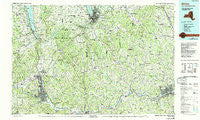
~ Elmira NY topo map, 1:100000 scale, 30 X 60 Minute, Historical, 1992, updated 1993
Elmira, New York, USGS topographic map dated 1992.
Includes geographic coordinates (latitude and longitude). This topographic map is suitable for hiking, camping, and exploring, or framing it as a wall map.
Printed on-demand using high resolution imagery, on heavy weight and acid free paper, or alternatively on a variety of synthetic materials.
Topos available on paper, Waterproof, Poly, or Tyvek. Usually shipping rolled, unless combined with other folded maps in one order.
- Product Number: USGS-5454659
- Free digital map download (high-resolution, GeoPDF): Elmira, New York (file size: 24 MB)
- Map Size: please refer to the dimensions of the GeoPDF map above
- Weight (paper map): ca. 55 grams
- Map Type: POD USGS Topographic Map
- Map Series: HTMC
- Map Verison: Historical
- Cell ID: 67475
- Scan ID: 137325
- Imprint Year: 1993
- Woodland Tint: Yes
- Visual Version Number: 1
- Aerial Photo Year: 1980
- Edit Year: 1986
- Datum: NAD27
- Map Projection: Universal Transverse Mercator
- Map published by United States Geological Survey
- Map Language: English
- Scanner Resolution: 600 dpi
- Map Cell Name: Elmira
- Grid size: 30 X 60 Minute
- Date on map: 1992
- Map Scale: 1:100000
- Geographical region: New York, United States
Neighboring Maps:
All neighboring USGS topo maps are available for sale online at a variety of scales.
Spatial coverage:
Topo map Elmira, New York, covers the geographical area associated the following places:
- Flemingville - Wildwood Mobile Home Park - Midway - Kintner Estates Mobile Home Park - Manningville - North Spencer - East Nichols - Danby - Erin Estates - White Church - Crest View Heights - Post Trailer Park - Deckertown - Maine - Bennettsburg - Pine Valley Mobile Home Park - Rosstown - Glenmary Mobile Home Park - Howland Mobile Home Park - Breesport - Owens Mills - Hullsville - Speedsville - Reynoldsville - Wedgewood - Cayuga Heights - Newfield - Richford - Lowman - Watkins Glen - Litchfield - Alpine Junction - Retirement Estates - Green Valley Mobile Home Park - Webb Mills - Horton Crossing - Glen Aubrey - Reading Center - Harford - East Virgil - Horseheads - Caroline Center - Dryden - Brookhaven - Crimson Mobile Home Court - Nichols - Ellis - Riverside Manor - West Elmira - Meadowbrook Park - Cloverland Park - Crestwood Mobile Home Park - Bethel Grove - Van Housen Mobile Home Park - Pleasant View Mobile Home Park - Van Dorn Corner - Enfield - Kennedy Corner - College View Trailer Park - Glenora - Glencairn - Caroline - Rolling Acres Mobile Home Park - Applegate Corner - Perry City - East Elmira - Fall Creek Parke - Goff Road Mobile Home Park - Straits Corners - Ketchumville - Forest Home - Pine Valley - Havana Glen Mobile Home Park - Catlin Hill - North Barton - Twining Trailer Park - Hubbardtown - Ellistown - South Apalachin - Quick Mobile Home Park - Ross Corners - Harris Hill Manor - Dewittsburg Park Housing Project - Townsend - West Newark - Beaver Dams - Bostwick Corners - Upper Fairfield - Foster - Shelter Valley Mobile Home Park - Krum Corner - Butternut Park - Besemer - Cayuta - Caroline - Maine Mobile Park - Stephens Mobile Home Community - Lapeer - Chemung - Millport
- Map Area ID: AREA42.542-77-76
- Northwest corner Lat/Long code: USGSNW42.5-77
- Northeast corner Lat/Long code: USGSNE42.5-76
- Southwest corner Lat/Long code: USGSSW42-77
- Southeast corner Lat/Long code: USGSSE42-76
- Northern map edge Latitude: 42.5
- Southern map edge Latitude: 42
- Western map edge Longitude: -77
- Eastern map edge Longitude: -76


