
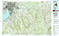
~ Buffalo NY topo map, 1:100000 scale, 30 X 60 Minute, Historical, 1984, updated 1994
Buffalo, New York, USGS topographic map dated 1984.
Includes geographic coordinates (latitude and longitude). This topographic map is suitable for hiking, camping, and exploring, or framing it as a wall map.
Printed on-demand using high resolution imagery, on heavy weight and acid free paper, or alternatively on a variety of synthetic materials.
Topos available on paper, Waterproof, Poly, or Tyvek. Usually shipping rolled, unless combined with other folded maps in one order.
- Product Number: USGS-5454645
- Free digital map download (high-resolution, GeoPDF): Buffalo, New York (file size: 25 MB)
- Map Size: please refer to the dimensions of the GeoPDF map above
- Weight (paper map): ca. 55 grams
- Map Type: POD USGS Topographic Map
- Map Series: HTMC
- Map Verison: Historical
- Cell ID: 72625
- Scan ID: 137133
- Imprint Year: 1994
- Woodland Tint: Yes
- Aerial Photo Year: 1981
- Edit Year: 1984
- Datum: NAD27
- Map Projection: Universal Transverse Mercator
- Map published by United States Geological Survey
- Map Language: English
- Scanner Resolution: 600 dpi
- Map Cell Name: Buffalo
- Grid size: 30 X 60 Minute
- Date on map: 1984
- Map Scale: 1:100000
- Geographical region: New York, United States
Neighboring Maps:
All neighboring USGS topo maps are available for sale online at a variety of scales.
Spatial coverage:
Topo map Buffalo, New York, covers the geographical area associated the following places:
- Java Village - Sucker Brook - Dutch Flats - Carefree Park Estates Mobile Home Park - Eagle - Waterfalls Village Mobile Home Park - Sierks - Bennington - Millers Crossing - Lake View - Batavia - North Boston - Water Valley - Millgrove - Niagara Mobile Home Park - Mount Vernon - Buffalo - Wiscoy - East Pembroke - Pinehurst - Hamburg - Chace - Thompsons Crossing - Big Tree Mobile Home Park - Eden - Dutch Hollow - Perry Center - Frinks Corner - Aristo Terrace Mobile Home Park - Pavilion - Wanakah - West Seneca - Williston - Lambs Corner - Gardenville - Alden - Arcade - Windom - Locksley Park - West Batavia - Crittenden - Triton Valley Estates Mobile Home Park - Pembroke Center - Hillside Terrace Mobile Home Park - Harris Corners - Websters Corners - Forest Glen - Jamison Road - Bush Gardens Mobile Home Park - Looneyville - Wyandale - Eggertsville - Folsomdale - Wales Hollow - Sunset Mobile Home Court - Armor - Brighton - Forks - Chaffee - Concord - Ellwood Park - Bowmansville - West Bethany - Sloan - Town Line Station - Patchin - North Gainesville - East Concord - Grandyle Village - Taylor Hollow - Langford - Elma Center - Martinsville - Pembroke - East Elma - East Bennington - South Wales - Attica Center - East Koy - Versailles - Holland - Grover Cleveland Terrace - Quarry Hill Estates Mobile Home Park - Spragues Corner - Varysburg - South Newstead - Murrays Corner - Morton Corners - Williamsville - Loveland - Frontier Mobile Home Park - Sheldon - Springville - Orchard Park - Silver Lake Junction - Shamrock Mobile Home Park - Hermitage Meadow Mobile Home Park - North Sheldon - Cheektowasa - Silver Lake
- Map Area ID: AREA4342.5-79-78
- Northwest corner Lat/Long code: USGSNW43-79
- Northeast corner Lat/Long code: USGSNE43-78
- Southwest corner Lat/Long code: USGSSW42.5-79
- Southeast corner Lat/Long code: USGSSE42.5-78
- Northern map edge Latitude: 43
- Southern map edge Latitude: 42.5
- Western map edge Longitude: -79
- Eastern map edge Longitude: -78


