
~ Binghamton NY topo map, 1:100000 scale, 30 X 60 Minute, Historical, 1985, updated 1993
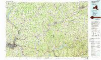
Binghamton, New York, USGS topographic map dated 1985.
Includes geographic coordinates (latitude and longitude). This topographic map is suitable for hiking, camping, and exploring, or framing it as a wall map.
Printed on-demand using high resolution imagery, on heavy weight and acid free paper, or alternatively on a variety of synthetic materials.
Topos available on paper, Waterproof, Poly, or Tyvek. Usually shipping rolled, unless combined with other folded maps in one order.
- Product Number: USGS-5454643
- Free digital map download (high-resolution, GeoPDF): Binghamton, New York (file size: 26 MB)
- Map Size: please refer to the dimensions of the GeoPDF map above
- Weight (paper map): ca. 55 grams
- Map Type: POD USGS Topographic Map
- Map Series: HTMC
- Map Verison: Historical
- Cell ID: 67140
- Scan ID: 137110
- Imprint Year: 1993
- Woodland Tint: Yes
- Photo Inspection Year: 1988
- Aerial Photo Year: 1982
- Edit Year: 1985
- Datum: NAD27
- Map Projection: Universal Transverse Mercator
- Map published by United States Geological Survey
- Map Language: English
- Scanner Resolution: 600 dpi
- Map Cell Name: Binghamton
- Grid size: 30 X 60 Minute
- Date on map: 1985
- Map Scale: 1:100000
- Geographical region: New York, United States
Neighboring Maps:
All neighboring USGS topo maps are available for sale online at a variety of scales.
Spatial coverage:
Topo map Binghamton, New York, covers the geographical area associated the following places:
- Rockdale - Port Dickinson - Whitman - Howes - West Meredith - Blatchley - West Oneonta - East Windsor - Belden - Ballards Mobile Home Park - Lees Mobile Home Park - Wyman Corner - Loomis - West Delhi - Conklin - Gregorytown - Popes Ravine - West Bainbridge - Kirkwood Center - Fickles Corner - Gulf Summit - Dibble Corner - Quinneville - Park Terrace - Blackesley Corner - Mundale - Harpursville - Bennettsville - Triangle - Flannerys Mobile Home Park - Hinmans Corners - Copes Corner - Castle Creek - Virginia City Mobile Home Court - Lower Genegantslet Corner - Yaleville - Stella (historical) - Barbourville - White Store - Arctic - Brookvale - New Ohio - Lester - Rock Rift - Lathams Corners - Forest Manor - Georgetown - Bettsburg - Langdon - Meadowbrooke Estates - Johnson City - Smithville Center - Penelope - Frone Corner - Sunrise Terrace - Fountain Blue Mobile Home Park - Sidney Center - Otego - Belden Hill - Mount Upton - Riverside Mobile Home Park - Fenton Mobile Home Park - Haynes - Corbin Corner - Masonville - New Ireland - Apex - McClure - Hawleyton - Adams Corner - Corbettsville - Kelsey Brook Trailer Court - Kirkwood - Gilbertsville - Dorchester Estates - Creekside Village - North Colesville - Beerston - Barnes Trailer Park - South Unadilla - Lakeview - Fortress Estates - Flowers - South Oxford - Oneida Village Mobile Home Park - Vallonia Springs - West End - North Sanford - Center Village - Conklin Station - Bainbridge - Cleaver - Pine Manor - Mill Creek Estates - Leonta - East Masonville - Summit Hill - West Chenango - Damascus - East McDonough
- Map Area ID: AREA42.542-76-75
- Northwest corner Lat/Long code: USGSNW42.5-76
- Northeast corner Lat/Long code: USGSNE42.5-75
- Southwest corner Lat/Long code: USGSSW42-76
- Southeast corner Lat/Long code: USGSSE42-75
- Northern map edge Latitude: 42.5
- Southern map edge Latitude: 42
- Western map edge Longitude: -76
- Eastern map edge Longitude: -75


