
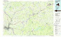
~ Binghamton NY topo map, 1:100000 scale, 30 X 60 Minute, Historical, 1985, updated 1986
Binghamton, New York, USGS topographic map dated 1985.
Includes geographic coordinates (latitude and longitude). This topographic map is suitable for hiking, camping, and exploring, or framing it as a wall map.
Printed on-demand using high resolution imagery, on heavy weight and acid free paper, or alternatively on a variety of synthetic materials.
Topos available on paper, Waterproof, Poly, or Tyvek. Usually shipping rolled, unless combined with other folded maps in one order.
- Product Number: USGS-5454641
- Free digital map download (high-resolution, GeoPDF): Binghamton, New York (file size: 17 MB)
- Map Size: please refer to the dimensions of the GeoPDF map above
- Weight (paper map): ca. 55 grams
- Map Type: POD USGS Topographic Map
- Map Series: HTMC
- Map Verison: Historical
- Cell ID: 67140
- Scan ID: 137108
- Imprint Year: 1986
- Woodland Tint: Yes
- Visual Version Number: 1
- Aerial Photo Year: 1982
- Edit Year: 1985
- Datum: NAD27
- Map Projection: Universal Transverse Mercator
- Planimetric: Yes
- Map published by United States Geological Survey
- Map Language: English
- Scanner Resolution: 600 dpi
- Map Cell Name: Binghamton
- Grid size: 30 X 60 Minute
- Date on map: 1985
- Map Scale: 1:100000
- Geographical region: New York, United States
Neighboring Maps:
All neighboring USGS topo maps are available for sale online at a variety of scales.
Spatial coverage:
Topo map Binghamton, New York, covers the geographical area associated the following places:
- Hydeville - Nineveh Junction - East Guilford - Rockdale - South Windsor - Bainbridge - Creekside Village - Hale Eddy - Lakeview - Oneonta - Lower Genegantslet Corner - Shinhopple - West Colesville - Readburn - Brooklyn - Rockwells Mills - Oxford - Heslops Corner - Howes - East Masonville - Merrickville - Parker - Gregorytown - Chenango Forks - Mundale - West Meredith - Whitman - Haynes - Smithville Flats - Kerry Siding - Coventry - South Unadilla - Frone Corner - Kattellville - Smithville Center - Gilbertsville - West Windsor - Treadwell - Corbett - Conklin Station - Oneida Village Mobile Home Park - Northfield - Kirkwood - Triangle - Apex - Ivanhoe - Center Village - Damascus - White Store - Adams Corner - Dibble Corner - Wyman Corner - Fortress Estates - Whitney Point - Upper Lisle - Kerryville - Chenango Bridge - Popes Ravine - North Franklin - Pinewoods Mobile Home Park - Mount Carmel - Harvard - Arabia - Wells Bridge - New Ireland - Bennettsville - Blatchley - Windsor - Wooded Estates - Kelsey Brook Trailer Court - Corbettsville - North Sanford - Stella (historical) - Hawleyton - Binghamton - Occanum Falls Mobile Home Park - Unadilla Center - Barnes Trailer Park - Fenton Mobile Home Park - Hambletville - Guilford Center - Page Brook - Centerville - Sanford - Masonville - Langdon - North Colesville - Union Valley - Belden - Youmans Corner - Hickory Ridge Mobile Home Park - Copes Corner - Hinmans Corners - German Four Corners - Sidney - Lees Mobile Home Park - Long Flat - Trout Creek - Franklin Depot - Port Dickinson
- Map Area ID: AREA42.542-76-75
- Northwest corner Lat/Long code: USGSNW42.5-76
- Northeast corner Lat/Long code: USGSNE42.5-75
- Southwest corner Lat/Long code: USGSSW42-76
- Southeast corner Lat/Long code: USGSSE42-75
- Northern map edge Latitude: 42.5
- Southern map edge Latitude: 42
- Western map edge Longitude: -76
- Eastern map edge Longitude: -75


