
~ Amsterdam NY topo map, 1:100000 scale, 30 X 60 Minute, Historical, 1985, updated 1986
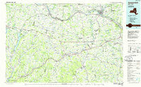
Amsterdam, New York, USGS topographic map dated 1985.
Includes geographic coordinates (latitude and longitude). This topographic map is suitable for hiking, camping, and exploring, or framing it as a wall map.
Printed on-demand using high resolution imagery, on heavy weight and acid free paper, or alternatively on a variety of synthetic materials.
Topos available on paper, Waterproof, Poly, or Tyvek. Usually shipping rolled, unless combined with other folded maps in one order.
- Product Number: USGS-5454633
- Free digital map download (high-resolution, GeoPDF): Amsterdam, New York (file size: 17 MB)
- Map Size: please refer to the dimensions of the GeoPDF map above
- Weight (paper map): ca. 55 grams
- Map Type: POD USGS Topographic Map
- Map Series: HTMC
- Map Verison: Historical
- Cell ID: 67045
- Scan ID: 137072
- Imprint Year: 1986
- Woodland Tint: Yes
- Visual Version Number: 1
- Aerial Photo Year: 1980
- Edit Year: 1985
- Datum: NAD27
- Map Projection: Universal Transverse Mercator
- Planimetric: Yes
- Map published by United States Geological Survey
- Map Language: English
- Scanner Resolution: 600 dpi
- Map Cell Name: Amsterdam
- Grid size: 30 X 60 Minute
- Date on map: 1985
- Map Scale: 1:100000
- Geographical region: New York, United States
Neighboring Maps:
All neighboring USGS topo maps are available for sale online at a variety of scales.
Spatial coverage:
Topo map Amsterdam, New York, covers the geographical area associated the following places:
- Marshville - Vorman Corners - Smith Corners - Cherry Valley - Thompsons Lake - Chaseville - Church Corners - Fonda - Huntersland - Rynex Corners - West Saint Johnsville - Root Center - Richfield Springs - Pleasant Brook - Stone Ridge - Wyatts - East Berne - Cliffside - Crescent Park - Breakabeen - Lincoln Mobile Home Park - Richmondville - Miller Corners - Knox - Glenville - Beards Hollow - Cobleskill - Browns Hollow - Staleyville - Old Central Bridge - Sloansville - Fultonville Mobile Home Park - Starkville - Oak Ridge - Sprout Brook - Sand Hill - Eaton Corners - Schoharie Junction - Westerlo - Hyndsville - Pail Shop Corners - Bramanville - Leesville - Middlefield Center - Mariaville - Schoharie - Scotch Church - Fort Plain - Quaker Street - Charleston Four Corners - Furnaceville - Hessville - Lower Corners - Rockton - Engleville - Cranesville - Kingdom - Hillcrest Mobile Home Park - Amsterdam - Fultonville - Clove - Canajoharie - Cooperstown - Burtonsville - Gallupville - Esperance - Franklinton - Stone Arabia - South Valley - Hagaman - Mapletown - Valley Brook - West Charlton - Dunnsville - East Township - Pine Meadow Mobile Home Park - Grovenor Corners - Center Valley - Dorloo - East Cobleskill - Duane Lake - South Worcester - Shady Lane Mobile Home Park - Warren - Hartwick Seminary - Yosts - Little York - Minaville - Fultonham - Charlotteville - Keesler Corners - Hawversville - Rensselaerville - Clintonville - Middle Village - Green Corners - Beyers Corners - Milford - Kelleys - Summit
- Map Area ID: AREA4342.5-75-74
- Northwest corner Lat/Long code: USGSNW43-75
- Northeast corner Lat/Long code: USGSNE43-74
- Southwest corner Lat/Long code: USGSSW42.5-75
- Southeast corner Lat/Long code: USGSSE42.5-74
- Northern map edge Latitude: 43
- Southern map edge Latitude: 42.5
- Western map edge Longitude: -75
- Eastern map edge Longitude: -74


