
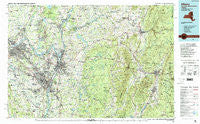
~ Albany NY topo map, 1:100000 scale, 30 X 60 Minute, Historical, 1989, updated 1989
Albany, New York, USGS topographic map dated 1989.
Includes geographic coordinates (latitude and longitude). This topographic map is suitable for hiking, camping, and exploring, or framing it as a wall map.
Printed on-demand using high resolution imagery, on heavy weight and acid free paper, or alternatively on a variety of synthetic materials.
Topos available on paper, Waterproof, Poly, or Tyvek. Usually shipping rolled, unless combined with other folded maps in one order.
- Product Number: USGS-5454631
- Free digital map download (high-resolution, GeoPDF): Albany, New York (file size: 26 MB)
- Map Size: please refer to the dimensions of the GeoPDF map above
- Weight (paper map): ca. 55 grams
- Map Type: POD USGS Topographic Map
- Map Series: HTMC
- Map Verison: Historical
- Cell ID: 72135
- Scan ID: 137059
- Imprint Year: 1989
- Woodland Tint: Yes
- Visual Version Number: 1
- Aerial Photo Year: 1986
- Edit Year: 1989
- Datum: NAD27
- Map Projection: Universal Transverse Mercator
- Map published by United States Geological Survey
- Map Language: English
- Scanner Resolution: 600 dpi
- Map Cell Name: Albany
- Grid size: 30 X 60 Minute
- Date on map: 1989
- Map Scale: 1:100000
- Geographical region: New York, United States
Neighboring Maps:
All neighboring USGS topo maps are available for sale online at a variety of scales.
Spatial coverage:
Topo map Albany, New York, covers the geographical area associated the following places:
- Ballston Lake - Petersburg - Clinton Heights - Center Cambridge - Castleton-on-Hudson - Stoodley Corners - Delmar - Parkers Corners - Silver Springs - Elnora - Hawthorne Hill - Speigletown - Renfrew - Bennington - Loudon Heights - Pleasantdale - Defreestville - Garfield - Hoosick - Keefers Corners - Loudonville - Hancock - Rotterdam - North Nassau - Brookview - John S Moore Homes - Groom Corners - Malta Gardens - Millers Corners - Stamford - Old Bennington - Bon Acre - Eastmor - Diamondwood Estates - Taborton - Karlsfeld - Spawn Hollow - Factory Hollow - Hoosick Falls - East Buskirk - Coons - Tomaselli Estates - Nassau - Bellevue - Terrace Haven Mobile Home Park - Bouplon Corner - Mechanicville - Williamstown - West Hoosick - Lincoln Park Homes - Stockbridge Manor - North Hoosick - Brayton Hill - Waterford - Eastern Summit - Beaver Dam (historical) - Orchard Park - Wyomanock - Northway Mobile Acres - Schonowe - Pine Haven Motor Home Park - Fox Wander West - Clifton Park Center - Creekside Mobile Home Park - Lisha Kill - Chuckleberry Mobile Home Park - Town Crest Village - Latham Mobile Home Court - Rosecrans Park - Hampton Manor - Cohoes - Johnsonville - East Saratoga Junciton - Rivers Mobile Home Park - Ballston Center - Watervliet - Cheshire Harbor - Pownal - Tamarack - Stillham - Hemstreet Park - Farnams - Boyntonville - Norton Street Mobile Home Park - Meilaks Mobile Home Court - South Schenectady - Adams - Camp Mohawk - Covered Wagon Court - Potter Hill - Bethlehem Center - Round Lake - Northway Mobile Home Estates - Maywood - Averill Park - Ushers - Alplaus - Lansingburgh - Grant Hollow - Menands
- Map Area ID: AREA4342.5-74-73
- Northwest corner Lat/Long code: USGSNW43-74
- Northeast corner Lat/Long code: USGSNE43-73
- Southwest corner Lat/Long code: USGSSW42.5-74
- Southeast corner Lat/Long code: USGSSE42.5-73
- Northern map edge Latitude: 43
- Southern map edge Latitude: 42.5
- Western map edge Longitude: -74
- Eastern map edge Longitude: -73


