
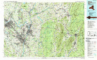
~ Albany NY topo map, 1:100000 scale, 30 X 60 Minute, Historical, 1989, updated 1989
Albany, New York, USGS topographic map dated 1989.
Includes geographic coordinates (latitude and longitude). This topographic map is suitable for hiking, camping, and exploring, or framing it as a wall map.
Printed on-demand using high resolution imagery, on heavy weight and acid free paper, or alternatively on a variety of synthetic materials.
Topos available on paper, Waterproof, Poly, or Tyvek. Usually shipping rolled, unless combined with other folded maps in one order.
- Product Number: USGS-5454629
- Free digital map download (high-resolution, GeoPDF): Albany, New York (file size: 26 MB)
- Map Size: please refer to the dimensions of the GeoPDF map above
- Weight (paper map): ca. 55 grams
- Map Type: POD USGS Topographic Map
- Map Series: HTMC
- Map Verison: Historical
- Cell ID: 72135
- Scan ID: 137058
- Imprint Year: 1989
- Woodland Tint: Yes
- Visual Version Number: 2
- Aerial Photo Year: 1986
- Edit Year: 1989
- Datum: NAD27
- Map Projection: Universal Transverse Mercator
- Map published by United States Geological Survey
- Map Language: English
- Scanner Resolution: 600 dpi
- Map Cell Name: Albany
- Grid size: 30 X 60 Minute
- Date on map: 1989
- Map Scale: 1:100000
- Geographical region: New York, United States
Neighboring Maps:
All neighboring USGS topo maps are available for sale online at a variety of scales.
Spatial coverage:
Topo map Albany, New York, covers the geographical area associated the following places:
- South Shaftsbury - Skipper Hill Farm - Mohawk View - Hungry Hill - Hampton Manor - Houcks Corners - Tarrytown - Petersburg Junction - South Cambridge - Center Cambridge - Canfield Trailer Park - The Spruces Mobile Home Park - Menands - Blackinton - White Oaks - East Saratoga Junciton - Whitcomb Summit - Coldbrook - Eastmor - Rosecrans Park - West Hoosick - Lone Pine Community Mobile Home Park - John S Moore Homes - High Mills - Bennington - Callanans Corners - Valley Falls - Country Knolls - Carmen Courts - East Renfrew - Stamford - Willow Lane Adult Trailer Park - Mourningkill Estates - Albany - Pleasantdale - Van Allen Park - Hemlock Brook (historical) - Pine Crest Trailer Park - Edgewood Estates - Savoy - Green Island - Collamer Park - Karner - New Scotland - Van Buren Park Homes - Ushers - Stillham - North Petersburg - Crescent City Mobile Home Park - Defreestville - Central Square Mobile Home Park - Grant Hollow - Northway Mobile Home Estates - East Greenbush - Oakwood Terrace - Maple Grove - Boyntonville - Halfmoon Beach - Hancock - Round Lake - Sweets Corner - East Grafton - Clums Corner - Savoy Center - Quackenkill - Meadowvale - Bethlehem Center - Pownal Center - Kenwood - Newtown - Halfmoon - Brunswick Center - Sodom - Tomhannock - Camp Mohawk - East Line - Hallum Trailer Park - Farnams - Barkers Grove - Rensselaer - Colonie - East Poestenkill - East Hoosick - White Creek - Latham - Town Crest Village - Nassau - Selkirk - Ralmar Park - Sherwood Park - North Bennington - Roessleville - Petersburg - Harmony Corners - Village of Alpenwald - West Stephentown - West Cambridge - Stony Point - Hampton Park - Brookview
- Map Area ID: AREA4342.5-74-73
- Northwest corner Lat/Long code: USGSNW43-74
- Northeast corner Lat/Long code: USGSNE43-73
- Southwest corner Lat/Long code: USGSSW42.5-74
- Southeast corner Lat/Long code: USGSSE42.5-73
- Northern map edge Latitude: 43
- Southern map edge Latitude: 42.5
- Western map edge Longitude: -74
- Eastern map edge Longitude: -73


