
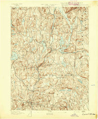
~ Carmel NY topo map, 1:62500 scale, 15 X 15 Minute, Historical, 1893
Carmel, New York, USGS topographic map dated 1893.
Includes geographic coordinates (latitude and longitude). This topographic map is suitable for hiking, camping, and exploring, or framing it as a wall map.
Printed on-demand using high resolution imagery, on heavy weight and acid free paper, or alternatively on a variety of synthetic materials.
Topos available on paper, Waterproof, Poly, or Tyvek. Usually shipping rolled, unless combined with other folded maps in one order.
- Product Number: USGS-5450947
- Free digital map download (high-resolution, GeoPDF): Carmel, New York (file size: 9 MB)
- Map Size: please refer to the dimensions of the GeoPDF map above
- Weight (paper map): ca. 55 grams
- Map Type: POD USGS Topographic Map
- Map Series: HTMC
- Map Verison: Historical
- Cell ID: 52195
- Scan ID: 140434
- Visual Version Number: 1
- Survey Year: 1890
- Datum: Unstated
- Map Projection: Unstated
- Map published by United States Geological Survey
- Map Language: English
- Scanner Resolution: 600 dpi
- Map Cell Name: Carmel
- Grid size: 15 X 15 Minute
- Date on map: 1893
- Map Scale: 1:62500
- Geographical region: New York, United States
Neighboring Maps:
All neighboring USGS topo maps are available for sale online at a variety of scales.
Spatial coverage:
Topo map Carmel, New York, covers the geographical area associated the following places:
- Drewville Heights - Kent Hills - Ridgebury - Fosters Corners - Allen Corners - Carmel Hills - Dykemans - Valley Pond Estates - Cross River - Grant Corner - Shenorock - Brewster Heights - Heritage Hills - Butlerville - Horton Estates - Field Corners - Sodom - Croton Falls - Steinbeck Corners - Katonah Ridge - Kent Corners - Lake Lincolndale - Putnam Lake - Doanesburgh (historical) - Lake Katonah - Mill Plain - Lincolndale - Valleyville - Elm Tree Corner - Gayville - Taylor Corners - Crafts - Berkshire Terrace - Farmers Mills - Bigelow Corners - Towners - Haines Corners - Carmel - Tilly Foster - Sears Corners - Katonah - Waccabuc - North Salem - Milltown - South Salem - Somers - Haviland Hollow - Peach Lake - Lake Purdy - Carmel Park Estates - Purdys - Goldens Bridge - Barnum Corners - Deans Corner - Titicus - Dingle - Boutonville - Whitehall Corners - Brewster Hill - Ball Pond - Lake Carmel - Couch Corners - McLaughlin Acres - Salem Center - Deforest Corners - Knolls Trailer Court - Brewster - Twin Lakes Village - Mahopac - Truesdale Lake
- Map Area ID: AREA41.541.25-73.75-73.5
- Northwest corner Lat/Long code: USGSNW41.5-73.75
- Northeast corner Lat/Long code: USGSNE41.5-73.5
- Southwest corner Lat/Long code: USGSSW41.25-73.75
- Southeast corner Lat/Long code: USGSSE41.25-73.5
- Northern map edge Latitude: 41.5
- Southern map edge Latitude: 41.25
- Western map edge Longitude: -73.75
- Eastern map edge Longitude: -73.5


