
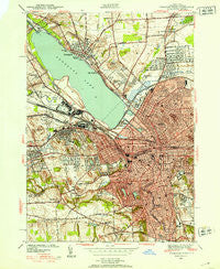
~ Syracuse West NY topo map, 1:24000 scale, 7.5 X 7.5 Minute, Historical, 1939
Syracuse West, New York, USGS topographic map dated 1939.
Includes geographic coordinates (latitude and longitude). This topographic map is suitable for hiking, camping, and exploring, or framing it as a wall map.
Printed on-demand using high resolution imagery, on heavy weight and acid free paper, or alternatively on a variety of synthetic materials.
Topos available on paper, Waterproof, Poly, or Tyvek. Usually shipping rolled, unless combined with other folded maps in one order.
- Product Number: USGS-5448892
- Free digital map download (high-resolution, GeoPDF): Syracuse West, New York (file size: 14 MB)
- Map Size: please refer to the dimensions of the GeoPDF map above
- Weight (paper map): ca. 55 grams
- Map Type: POD USGS Topographic Map
- Map Series: HTMC
- Map Verison: Historical
- Cell ID: 71779
- Scan ID: 139952
- Woodland Tint: Yes
- Visual Version Number: 1
- Survey Year: 1939
- Datum: NAD27
- Map Projection: Polyconic
- Map published by United States Geological Survey
- Map Language: English
- Scanner Resolution: 600 dpi
- Map Cell Name: Syracuse West
- Grid size: 7.5 X 7.5 Minute
- Date on map: 1939
- Map Scale: 1:24000
- Geographical region: New York, United States
Neighboring Maps:
All neighboring USGS topo maps are available for sale online at a variety of scales.
Spatial coverage:
Topo map Syracuse West, New York, covers the geographical area associated the following places:
- Syracuse - Lemoyne Mobile Home Park - Onondaga Hill - Westvale - Pitcher Hill - Hinsdale - Pleasant View - Galeville - Split Rock - Taunton - Fairmount - Solvay - Long Branch - Lyncourt - Lakeland - Liverpool - Loomis Hill - Mattydale
- Map Area ID: AREA43.12543-76.25-76.125
- Northwest corner Lat/Long code: USGSNW43.125-76.25
- Northeast corner Lat/Long code: USGSNE43.125-76.125
- Southwest corner Lat/Long code: USGSSW43-76.25
- Southeast corner Lat/Long code: USGSSE43-76.125
- Northern map edge Latitude: 43.125
- Southern map edge Latitude: 43
- Western map edge Longitude: -76.25
- Eastern map edge Longitude: -76.125


