
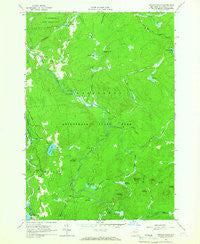
~ Sylvan Falls NY topo map, 1:24000 scale, 7.5 X 7.5 Minute, Historical, 1964, updated 1966
Sylvan Falls, New York, USGS topographic map dated 1964.
Includes geographic coordinates (latitude and longitude). This topographic map is suitable for hiking, camping, and exploring, or framing it as a wall map.
Printed on-demand using high resolution imagery, on heavy weight and acid free paper, or alternatively on a variety of synthetic materials.
Topos available on paper, Waterproof, Poly, or Tyvek. Usually shipping rolled, unless combined with other folded maps in one order.
- Product Number: USGS-5448874
- Free digital map download (high-resolution, GeoPDF): Sylvan Falls, New York (file size: 9 MB)
- Map Size: please refer to the dimensions of the GeoPDF map above
- Weight (paper map): ca. 55 grams
- Map Type: POD USGS Topographic Map
- Map Series: HTMC
- Map Verison: Historical
- Cell ID: 44081
- Scan ID: 139936
- Imprint Year: 1966
- Woodland Tint: Yes
- Visual Version Number: 1
- Aerial Photo Year: 1963
- Field Check Year: 1964
- Datum: NAD27
- Map Projection: Polyconic
- Map published by United States Geological Survey
- Map Language: English
- Scanner Resolution: 600 dpi
- Map Cell Name: Sylvan Falls
- Grid size: 7.5 X 7.5 Minute
- Date on map: 1964
- Map Scale: 1:24000
- Geographical region: New York, United States
Neighboring Maps:
All neighboring USGS topo maps are available for sale online at a variety of scales.
Spatial coverage:
Topo map Sylvan Falls, New York, covers the geographical area associated the following places:
- Fenner Meadows - Randle Meadows - Sugar Grove Mountain - Thomas Brook - Sugar Grove Pass - Flower Hill - Sterling Pond - The Bog - Willis Brook - Balsam Brook - Harper School (historical) - Mud Pond Outlet - Dead Creek - Mud Pond - Slough Pond - Cooperage Club - Hopkinton Pond - Coffee Mountain - Welch Brook - Randle Meadow Brook - Randle Meadow Brook - Saint Lawrence State Forest Number 8 - Sylvan Falls - Loon Mountain - The Bog Outlet - Santimaw Brook - Fenner Meadow Brook - Bruner Falls - Town of Hopkinton - Coulon Cemetery - Stony Brook - Twin Ponds - Kingsley Falls - Hogback Brook - Wick School (historical) - Hamilton Mountain - Bear Mountain - Sterling Pond Outlet - School Number 13 (historical)
- Map Area ID: AREA44.62544.5-74.75-74.625
- Northwest corner Lat/Long code: USGSNW44.625-74.75
- Northeast corner Lat/Long code: USGSNE44.625-74.625
- Southwest corner Lat/Long code: USGSSW44.5-74.75
- Southeast corner Lat/Long code: USGSSE44.5-74.625
- Northern map edge Latitude: 44.625
- Southern map edge Latitude: 44.5
- Western map edge Longitude: -74.75
- Eastern map edge Longitude: -74.625


