
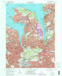
~ Sea Cliff NY topo map, 1:24000 scale, 7.5 X 7.5 Minute, Historical, 1968, updated 1979
Sea Cliff, New York, USGS topographic map dated 1968.
Includes geographic coordinates (latitude and longitude). This topographic map is suitable for hiking, camping, and exploring, or framing it as a wall map.
Printed on-demand using high resolution imagery, on heavy weight and acid free paper, or alternatively on a variety of synthetic materials.
Topos available on paper, Waterproof, Poly, or Tyvek. Usually shipping rolled, unless combined with other folded maps in one order.
- Product Number: USGS-5448506
- Free digital map download (high-resolution, GeoPDF): Sea Cliff, New York (file size: 18 MB)
- Map Size: please refer to the dimensions of the GeoPDF map above
- Weight (paper map): ca. 55 grams
- Map Type: POD USGS Topographic Map
- Map Series: HTMC
- Map Verison: Historical
- Cell ID: 71545
- Scan ID: 136118
- Imprint Year: 1979
- Woodland Tint: Yes
- Photo Revision Year: 1979
- Aerial Photo Year: 1976
- Edit Year: 1979
- Datum: NAD27
- Map Projection: Polyconic
- Map published by United States Geological Survey
- Map Language: English
- Scanner Resolution: 600 dpi
- Map Cell Name: Sea Cliff
- Grid size: 7.5 X 7.5 Minute
- Date on map: 1968
- Map Scale: 1:24000
- Geographical region: New York, United States
Neighboring Maps:
All neighboring USGS topo maps are available for sale online at a variety of scales.
Spatial coverage:
Topo map Sea Cliff, New York, covers the geographical area associated the following places:
- Plandome - Strathmore - Thomaston - South Glenwood Landing - Roslyn Heights - University Gardens - Great Neck - Kings Point - Harbor Hills - Manorhaven - Plandome Manor - Russell Gardens - Flower Hill - Douglaston - Roslyn Estates - Kensington - East Williston - Sea Cliff - Williston Park - Roslyn Harbor - Glenwood Landing - East Hills - East Atlantic Beach - Great Neck Plaza - Port Washington - Great Neck Estates - Hillside Manor - Great Neck Gardens - Saddle Rock Estates - Munsey Park - Greenvale - North Hills - Manhasset - Herricks - Plandome Heights - Albertson - Lake Success - Saddle Rock - Little Neck - Sands Point - Port Washington North - Glen Cove Landing - Glen Cove - Manhasset Hills - Baxter Estates - Roslyn - Searingtown
- Map Area ID: AREA40.87540.75-73.75-73.625
- Northwest corner Lat/Long code: USGSNW40.875-73.75
- Northeast corner Lat/Long code: USGSNE40.875-73.625
- Southwest corner Lat/Long code: USGSSW40.75-73.75
- Southeast corner Lat/Long code: USGSSE40.75-73.625
- Northern map edge Latitude: 40.875
- Southern map edge Latitude: 40.75
- Western map edge Longitude: -73.75
- Eastern map edge Longitude: -73.625


