
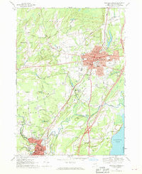
~ Saratoga Springs NY topo map, 1:24000 scale, 7.5 X 7.5 Minute, Historical, 1967, updated 1969
Saratoga Springs, New York, USGS topographic map dated 1967.
Includes geographic coordinates (latitude and longitude). This topographic map is suitable for hiking, camping, and exploring, or framing it as a wall map.
Printed on-demand using high resolution imagery, on heavy weight and acid free paper, or alternatively on a variety of synthetic materials.
Topos available on paper, Waterproof, Poly, or Tyvek. Usually shipping rolled, unless combined with other folded maps in one order.
- Product Number: USGS-5448412
- Free digital map download (high-resolution, GeoPDF): Saratoga Springs, New York (file size: 10 MB)
- Map Size: please refer to the dimensions of the GeoPDF map above
- Weight (paper map): ca. 55 grams
- Map Type: POD USGS Topographic Map
- Map Series: HTMC
- Map Verison: Historical
- Cell ID: 39968
- Scan ID: 129389
- Imprint Year: 1969
- Woodland Tint: Yes
- Visual Version Number: 1
- Aerial Photo Year: 1964
- Field Check Year: 1967
- Datum: NAD27
- Map Projection: Polyconic
- Map published by United States Geological Survey
- Map Language: English
- Scanner Resolution: 600 dpi
- Map Cell Name: Saratoga Springs
- Grid size: 7.5 X 7.5 Minute
- Date on map: 1967
- Map Scale: 1:24000
- Geographical region: New York, United States
Neighboring Maps:
All neighboring USGS topo maps are available for sale online at a variety of scales.
Spatial coverage:
Topo map Saratoga Springs, New York, covers the geographical area associated the following places:
- Saratoga West Mobile Home Park - Grange Road Mobile Estates - Milton Manor - Country Acres Trailer Park - Country Manor Trailer Court - Evergreen Point - Eddy Corners - Geyser Gates - Loughberry Mobile Home Park - Saratoga Mobile Home Park - South Greenfield - Chris Mobile Home Park - Independence Square - Victoria Gardens - Milton Heights - Riley Cove - Factory Village - Heritage Manor - Coachman Estates - Francis Corners - Saratoga Estates - Lakewood Estates - Travers Manor - Milton Oaks - Greenfield - Ballston Spa - Utters Mobile Home Park - Daniel Corners Trailer Park - Brookview Village Mobile Home Park - Woodland Court - The Meadows - Sabre Springs - Country Squire Estates - The Springs - Juniper Acres - Yaddo - Geyser Crest - Sherwood Forest - Malta Ridge - Saratoga Springs - Milton - Trotterview Trailer Park - Deer Run - Hidden Acres Mobile Court - Lakeside Acres - Mannings Cove - Birch Acres - Birch Run
- Map Area ID: AREA43.12543-73.875-73.75
- Northwest corner Lat/Long code: USGSNW43.125-73.875
- Northeast corner Lat/Long code: USGSNE43.125-73.75
- Southwest corner Lat/Long code: USGSSW43-73.875
- Southeast corner Lat/Long code: USGSSE43-73.75
- Northern map edge Latitude: 43.125
- Southern map edge Latitude: 43
- Western map edge Longitude: -73.875
- Eastern map edge Longitude: -73.75


