
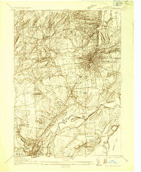
~ Saratoga Springs NY topo map, 1:24000 scale, 7.5 X 7.5 Minute, Historical, 1934
Saratoga Springs, New York, USGS topographic map dated 1934.
Includes geographic coordinates (latitude and longitude). This topographic map is suitable for hiking, camping, and exploring, or framing it as a wall map.
Printed on-demand using high resolution imagery, on heavy weight and acid free paper, or alternatively on a variety of synthetic materials.
Topos available on paper, Waterproof, Poly, or Tyvek. Usually shipping rolled, unless combined with other folded maps in one order.
- Product Number: USGS-5448408
- Free digital map download (high-resolution, GeoPDF): Saratoga Springs, New York (file size: 11 MB)
- Map Size: please refer to the dimensions of the GeoPDF map above
- Weight (paper map): ca. 55 grams
- Map Type: POD USGS Topographic Map
- Map Series: HTMC
- Map Verison: Historical
- Cell ID: 39968
- Scan ID: 129387
- Visual Version Number: 1
- Survey Year: 1934
- Datum: NAD27
- Map Projection: Polyconic
- Advance: Yes
- Map published by United States Geological Survey
- Keywords: Nonstandard Press Run
- Map Language: English
- Scanner Resolution: 600 dpi
- Map Cell Name: Saratoga Springs
- Grid size: 7.5 X 7.5 Minute
- Date on map: 1934
- Map Scale: 1:24000
- Geographical region: New York, United States
Neighboring Maps:
All neighboring USGS topo maps are available for sale online at a variety of scales.
Spatial coverage:
Topo map Saratoga Springs, New York, covers the geographical area associated the following places:
- Utters Mobile Home Park - Geyser Crest - Saratoga Springs - Woodland Court - Juniper Acres - Evergreen Point - Malta Ridge - Birch Run - Birch Acres - Country Acres Trailer Park - Deer Run - Lakewood Estates - Loughberry Mobile Home Park - Mannings Cove - Grange Road Mobile Estates - Geyser Gates - Travers Manor - Country Manor Trailer Court - Chris Mobile Home Park - South Greenfield - Sabre Springs - Greenfield - Factory Village - Saratoga Estates - Brookview Village Mobile Home Park - Trotterview Trailer Park - Heritage Manor - Francis Corners - Milton Oaks - Eddy Corners - Ballston Spa - Milton Manor - Hidden Acres Mobile Court - Milton - Saratoga West Mobile Home Park - Sherwood Forest - The Meadows - Independence Square - The Springs - Coachman Estates - Milton Heights - Saratoga Mobile Home Park - Victoria Gardens - Yaddo - Country Squire Estates - Daniel Corners Trailer Park - Lakeside Acres - Riley Cove
- Map Area ID: AREA43.12543-73.875-73.75
- Northwest corner Lat/Long code: USGSNW43.125-73.875
- Northeast corner Lat/Long code: USGSNE43.125-73.75
- Southwest corner Lat/Long code: USGSSW43-73.875
- Southeast corner Lat/Long code: USGSSE43-73.75
- Northern map edge Latitude: 43.125
- Southern map edge Latitude: 43
- Western map edge Longitude: -73.875
- Eastern map edge Longitude: -73.75


