
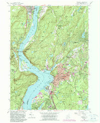
~ Peekskill NY topo map, 1:24000 scale, 7.5 X 7.5 Minute, Historical, 1957, updated 1990
Peekskill, New York, USGS topographic map dated 1957.
Includes geographic coordinates (latitude and longitude). This topographic map is suitable for hiking, camping, and exploring, or framing it as a wall map.
Printed on-demand using high resolution imagery, on heavy weight and acid free paper, or alternatively on a variety of synthetic materials.
Topos available on paper, Waterproof, Poly, or Tyvek. Usually shipping rolled, unless combined with other folded maps in one order.
- Product Number: USGS-5447754
- Free digital map download (high-resolution, GeoPDF): Peekskill, New York (file size: 15 MB)
- Map Size: please refer to the dimensions of the GeoPDF map above
- Weight (paper map): ca. 55 grams
- Map Type: POD USGS Topographic Map
- Map Series: HTMC
- Map Verison: Historical
- Cell ID: 34617
- Scan ID: 136785
- Imprint Year: 1990
- Woodland Tint: Yes
- Visual Version Number: 3
- Photo Revision Year: 1981
- Aerial Photo Year: 1976
- Edit Year: 1981
- Field Check Year: 1957
- Datum: NAD27
- Map Projection: Polyconic
- Map published by United States Geological Survey
- Map Language: English
- Scanner Resolution: 600 dpi
- Map Cell Name: Peekskill
- Grid size: 7.5 X 7.5 Minute
- Date on map: 1957
- Map Scale: 1:24000
- Geographical region: New York, United States
Neighboring Maps:
All neighboring USGS topo maps are available for sale online at a variety of scales.
Spatial coverage:
Topo map Peekskill, New York, covers the geographical area associated the following places:
- Tomkins Cove - Fort Clinton - Hudson View Terrace Mobile Home Park - Highland Falls - Peekskill - Continental Village - Verplanck - Glenclyffe - Toddville - Forsonville - Manitou - Annsville - Westpoint Mobile Home Park - Roe Park - Gallows Hill - Van Cortlandtville - Graymoor - Pleasantside - Finktown - Montrose - Furnace Woods - Buckberg - Lake Peekskill - Buchanan - Fort Montgomery - Jones Point
- Map Area ID: AREA41.37541.25-74-73.875
- Northwest corner Lat/Long code: USGSNW41.375-74
- Northeast corner Lat/Long code: USGSNE41.375-73.875
- Southwest corner Lat/Long code: USGSSW41.25-74
- Southeast corner Lat/Long code: USGSSE41.25-73.875
- Northern map edge Latitude: 41.375
- Southern map edge Latitude: 41.25
- Western map edge Longitude: -74
- Eastern map edge Longitude: -73.875


