
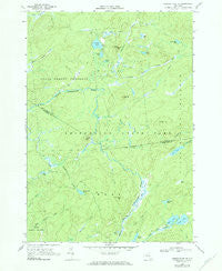
~ Oswegatchie SE NY topo map, 1:24000 scale, 7.5 X 7.5 Minute, Historical, 1966, updated 1984
Oswegatchie SE, New York, USGS topographic map dated 1966.
Includes geographic coordinates (latitude and longitude). This topographic map is suitable for hiking, camping, and exploring, or framing it as a wall map.
Printed on-demand using high resolution imagery, on heavy weight and acid free paper, or alternatively on a variety of synthetic materials.
Topos available on paper, Waterproof, Poly, or Tyvek. Usually shipping rolled, unless combined with other folded maps in one order.
- Product Number: USGS-5447566
- Free digital map download (high-resolution, GeoPDF): Oswegatchie SE, New York (file size: 11 MB)
- Map Size: please refer to the dimensions of the GeoPDF map above
- Weight (paper map): ca. 55 grams
- Map Type: POD USGS Topographic Map
- Map Series: HTMC
- Map Verison: Historical
- Cell ID: 33579
- Scan ID: 135920
- Imprint Year: 1984
- Woodland Tint: Yes
- Photo Inspection Year: 1980
- Aerial Photo Year: 1966
- Field Check Year: 1966
- Datum: NAD27
- Map Projection: Polyconic
- Map published by United States Geological Survey
- Map Language: English
- Scanner Resolution: 600 dpi
- Map Cell Name: Oswegatchie SE
- Grid size: 7.5 X 7.5 Minute
- Date on map: 1966
- Map Scale: 1:24000
- Geographical region: New York, United States
Neighboring Maps:
All neighboring USGS topo maps are available for sale online at a variety of scales.
Spatial coverage:
Topo map Oswegatchie SE, New York, covers the geographical area associated the following places:
- Kelley Pond - Pine Pond - Sand Lake - Moncrief Creek - Deer Marsh - Round Hill - Bassetts Creek - Crystal Lake - Maple Hill - Wolf Pond - Sitz Creek - Alder Bed Flow - Streeter Lake Outlet - Pins Creek - Wolf Creek - Grassy Pond - Emerald Lake - Francis Hill - Pansy Pond - Massawepie Creek - Alder Bed Mountain - Lees Creek - Streeter Mountain - Rock Lake - Little Otter Pond Outlet - Cage Lake - Glasby Creek - Streeter Lake - Little Otter Pond - Coyer Creek - Mud Pond - Massawepie Pond
- Map Area ID: AREA44.12544-75.125-75
- Northwest corner Lat/Long code: USGSNW44.125-75.125
- Northeast corner Lat/Long code: USGSNE44.125-75
- Southwest corner Lat/Long code: USGSSW44-75.125
- Southeast corner Lat/Long code: USGSSE44-75
- Northern map edge Latitude: 44.125
- Southern map edge Latitude: 44
- Western map edge Longitude: -75.125
- Eastern map edge Longitude: -75


