
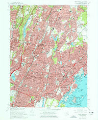
~ Mount Vernon NY topo map, 1:24000 scale, 7.5 X 7.5 Minute, Historical, 1966, updated 1977
Mount Vernon, New York, USGS topographic map dated 1966.
Includes geographic coordinates (latitude and longitude). This topographic map is suitable for hiking, camping, and exploring, or framing it as a wall map.
Printed on-demand using high resolution imagery, on heavy weight and acid free paper, or alternatively on a variety of synthetic materials.
Topos available on paper, Waterproof, Poly, or Tyvek. Usually shipping rolled, unless combined with other folded maps in one order.
- Product Number: USGS-5447156
- Free digital map download (high-resolution, GeoPDF): Mount Vernon, New York (file size: 19 MB)
- Map Size: please refer to the dimensions of the GeoPDF map above
- Weight (paper map): ca. 55 grams
- Map Type: POD USGS Topographic Map
- Map Series: HTMC
- Map Verison: Historical
- Cell ID: 70998
- Scan ID: 130720
- Imprint Year: 1977
- Woodland Tint: Yes
- Visual Version Number: 1
- Aerial Photo Year: 1966
- Field Check Year: 1966
- Datum: NAD27
- Map Projection: Polyconic
- Map published by United States Geological Survey
- Map Language: English
- Scanner Resolution: 600 dpi
- Map Cell Name: Mount Vernon
- Grid size: 7.5 X 7.5 Minute
- Date on map: 1966
- Map Scale: 1:24000
- Geographical region: New York, United States
Neighboring Maps:
All neighboring USGS topo maps are available for sale online at a variety of scales.
Spatial coverage:
Topo map Mount Vernon, New York, covers the geographical area associated the following places:
- Vernon Park - Dunwoodie - Bronxville - Residence Park - Gramatan Hills - Cecil Park - Beverly Crest - Victory Park - Heathcote - Greens At Cherry Lawn - Mount Vernon - Elmsmere - Huguenot Park - Pelham Manor - Rochelle Park - Mohegan Heights - Gunther Park - Secor Gardens - Grey Oaks - Woodlawn - Dunwoodie Heights - Isle of San Souci - Nepera Park - Chester Heights - Crestwood - Empire Park - New Rochelle - Quaker Ridge - Colonial Acres - Heath Ridge - North Pelham - Wakefield - Crestwood Gardens - White Birches - West Mount Vernon - Fleetwood - Scarsdale Downs - Baychester Houses - Sun Haven - Bonnie Crest - Arthur Manor - Cotswold - Wilmot Woods - Wykagyl - Rochelle Heights - Scarsdale Park - Homestead Park - Waverly - Nepperhan Heights - Murray Hill - Moorelands - Edenwald Houses - Halcyon Park - Forest Knolls - Parkside - Cedar Knolls - Greenville - Eastchester Heights - Bryn Mawr Park - Nepperhan - Chester Hill Park - Eastchester - Larchmont - Colonial Heights - Maplewood - Bayberry Park - Lawrence Park - Sunny Brae - Woodside - Forest Heights - Beechmont - Williams Bridge - Beechmont Woods - Eastchester - Pinebrook Heights - Murdock Woods - Wykagyl Park - McLean Heights - Gun Hill Houses - Pinebrook - Lincoln Heights - Mount Hope - Rosedale - Beech Hill - Bronxville Heights - Pelham - Pine Brook - Tuckahoe - Pinckney Heights
- Map Area ID: AREA4140.875-73.875-73.75
- Northwest corner Lat/Long code: USGSNW41-73.875
- Northeast corner Lat/Long code: USGSNE41-73.75
- Southwest corner Lat/Long code: USGSSW40.875-73.875
- Southeast corner Lat/Long code: USGSSE40.875-73.75
- Northern map edge Latitude: 41
- Southern map edge Latitude: 40.875
- Western map edge Longitude: -73.875
- Eastern map edge Longitude: -73.75


