
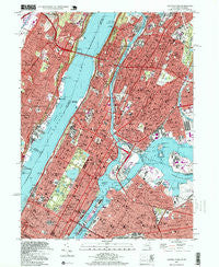
~ Central Park NY topo map, 1:24000 scale, 7.5 X 7.5 Minute, Historical, 1995, updated 1999
Central Park, New York, USGS topographic map dated 1995.
Includes geographic coordinates (latitude and longitude). This topographic map is suitable for hiking, camping, and exploring, or framing it as a wall map.
Printed on-demand using high resolution imagery, on heavy weight and acid free paper, or alternatively on a variety of synthetic materials.
Topos available on paper, Waterproof, Poly, or Tyvek. Usually shipping rolled, unless combined with other folded maps in one order.
- Product Number: USGS-5444868
- Free digital map download (high-resolution, GeoPDF): Central Park, New York (file size: 20 MB)
- Map Size: please refer to the dimensions of the GeoPDF map above
- Weight (paper map): ca. 55 grams
- Map Type: POD USGS Topographic Map
- Map Series: HTMC
- Map Verison: Historical
- Cell ID: 7974
- Scan ID: 137165
- Imprint Year: 1999
- Woodland Tint: Yes
- Photo Inspection Year: 1995
- Aerial Photo Year: 1997
- Datum: NAD27
- Map Projection: Transverse Mercator
- Map published by United States Geological Survey
- Map Language: English
- Scanner Resolution: 600 dpi
- Map Cell Name: Central Park
- Grid size: 7.5 X 7.5 Minute
- Date on map: 1995
- Map Scale: 1:24000
- Geographical region: New York, United States
Neighboring Maps:
All neighboring USGS topo maps are available for sale online at a variety of scales.
Spatial coverage:
Topo map Central Park, New York, covers the geographical area associated the following places:
- Hamilton Heights - Jackson Heights - Harsenville (historical) - Edgewater - Inwood - Saint Mary's Park Houses - Manhattan - San Juan Hill - Fordham - Forest Houses - Upper West Side - Colonial Park Houses - Charlotte Gardens - Esplanade Gardens - Lambert Houses - Plaza Borinquen - Park West Village - East Harlem - Sedgwick Houses - Jackson Houses - Lewis S Davidson Senior Houses - Konaande Kongh (historical) - University Heights - Manhattanville - East Tremont - Gouverneur Morris Houses - Harlem River Houses - Sugar Hill - Mill Brook Houses - John Adams Houses - North Beach - Tremont - Highbridge Houses - Hell's Kitchen - Belmont - Fairview - Seneca Village (historical) - Fort Lee - Taino Towers - Stanley Isaacs Houses - Dyckman Houses - West Farms - Fordham Hill - Morris Heights - Astoria - Borgia Butler Houses - Soundview Park Homes - Steinway - Cliffside Park - Franklin Houses - Melrose Houses - William McKinley Houses - Hamilton Houses - Melrose - Carmansville (historical) - Ravenswood Houses - Hunts Point - High Bridge - Riverbend Houses - Morrisania - Linwood - Mott Haven - Carnegie Hill - Port Morris - Phipps Houses - Harbor View Terrace - Morningside Heights - Gracie Square - Leonia - Coytesville - Bedford Park - Patterson Houses - Amsterdam Houses - Polo Grounds Houses - Kings Bridge Heights - Yorkville - Harlem - Lionel Hampton Houses - Concourse Village - Palisades Park - Clinton - Daniel Webster Houses - Garden Bay Manor - Charlotteville (historical) - Woodside Houses - Plaza De Los Angeles - Bronx River Houses - Le Petit Senegal - Delano Village - Queensbridge Houses - Grantwood - James Weldon Johnson Houses - Washington Heights
- Map Area ID: AREA40.87540.75-74-73.875
- Northwest corner Lat/Long code: USGSNW40.875-74
- Northeast corner Lat/Long code: USGSNE40.875-73.875
- Southwest corner Lat/Long code: USGSSW40.75-74
- Southeast corner Lat/Long code: USGSSE40.75-73.875
- Northern map edge Latitude: 40.875
- Southern map edge Latitude: 40.75
- Western map edge Longitude: -74
- Eastern map edge Longitude: -73.875


