
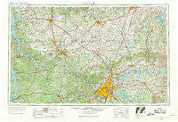
~ Nashville TN topo map, 1:250000 scale, 1 X 2 Degree, Historical, 1956, updated 1971
Nashville, Tennessee, USGS topographic map dated 1956.
Includes geographic coordinates (latitude and longitude). This topographic map is suitable for hiking, camping, and exploring, or framing it as a wall map.
Printed on-demand using high resolution imagery, on heavy weight and acid free paper, or alternatively on a variety of synthetic materials.
Topos available on paper, Waterproof, Poly, or Tyvek. Usually shipping rolled, unless combined with other folded maps in one order.
- Product Number: USGS-5339256
- Free digital map download (high-resolution, GeoPDF): Nashville, Tennessee (file size: 19 MB)
- Map Size: please refer to the dimensions of the GeoPDF map above
- Weight (paper map): ca. 55 grams
- Map Type: POD USGS Topographic Map
- Map Series: HTMC
- Map Verison: Historical
- Cell ID: 68928
- Scan ID: 149143
- Imprint Year: 1971
- Woodland Tint: Yes
- Aerial Photo Year: 1953
- Edit Year: 1969
- Field Check Year: 1956
- Datum: Unstated
- Map Projection: Transverse Mercator
- Map published by United States Geological Survey
- Map Language: English
- Scanner Resolution: 600 dpi
- Map Cell Name: Nashville
- Grid size: 1 X 2 Degree
- Date on map: 1956
- Map Scale: 1:250000
- Geographical region: Tennessee, United States
Neighboring Maps:
All neighboring USGS topo maps are available for sale online at a variety of scales.
Spatial coverage:
Topo map Nashville, Tennessee, covers the geographical area associated the following places:
- Kedron (historical) - Temperance - Youngville - Pleasant Run (historical) - Cross Roads - Sneed Glen - Vanleer - Stewart - Gap of the Ridge - Kinneys - Hinton Crossing - McEwen - Withamtown - Ashbury (historical) - Knollwood - Richland - Epleys - White Kitchen (historical) - Pomona - Everett - Cardinal Acres - Elkton - Cherry Grove - Ocana - New Providence - Hickory Flat - Pleasant Hill - White Hill - Lost River - Bon Air - Martha - Mount Zion - Pleasant Valley - Sneed Forest Estates - Crunk - Tater Peeler (historical) - Edgoten - New Hope - Bakersworks - Laytonsville (historical) - Carlisle - Turnersville - Flat Rock - Devonshire Manor - Old Zion (historical) - Baggettsville - Concord (historical) - Collett (historical) - Rich Pond - Concord - Tiny Town - Buena Vista Estates - Railton - Monticello - Lakeside Park - Adolphus - Maple Hill - Ruskin - Eno - Hickory Point - Cedar Grove - Jordan Springs (historical) - Doddsville - Sherrilltown - Fairview - LaFayette - Dripping Spring (historical) - Lost City - Meadowvale - Townsend Grove (historical) - Cedar Grove (historical) - Crestmoor - Peedee - East Dickson - Hampton Station - River Run - Griffintown - Shaver Town - Indian Mound - Dunbar Cave - Browning - Templow - Iroquois Meadows - Stony Point - Linwood - Clydeton (historical) - Vine - Hickory Valley Estates - Port Oliver Ford - Ranch Hill - Beverly Heights - Hadensville - Barkwood - Knobs (historical) - Adams Grove - Woodhaven (historical) - Pembroke - Cedar Hill - Riddleton - Caledonia
- Map Area ID: AREA3736-88-86
- Northwest corner Lat/Long code: USGSNW37-88
- Northeast corner Lat/Long code: USGSNE37-86
- Southwest corner Lat/Long code: USGSSW36-88
- Southeast corner Lat/Long code: USGSSE36-86
- Northern map edge Latitude: 37
- Southern map edge Latitude: 36
- Western map edge Longitude: -88
- Eastern map edge Longitude: -86


