
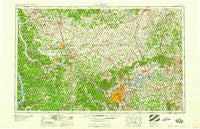
~ Nashville TN topo map, 1:250000 scale, 1 X 2 Degree, Historical, 1959
Nashville, Tennessee, USGS topographic map dated 1959.
Includes geographic coordinates (latitude and longitude). This topographic map is suitable for hiking, camping, and exploring, or framing it as a wall map.
Printed on-demand using high resolution imagery, on heavy weight and acid free paper, or alternatively on a variety of synthetic materials.
Topos available on paper, Waterproof, Poly, or Tyvek. Usually shipping rolled, unless combined with other folded maps in one order.
- Product Number: USGS-5339250
- Free digital map download (high-resolution, GeoPDF): Nashville, Tennessee (file size: 20 MB)
- Map Size: please refer to the dimensions of the GeoPDF map above
- Weight (paper map): ca. 55 grams
- Map Type: POD USGS Topographic Map
- Map Series: HTMC
- Map Verison: Historical
- Cell ID: 68928
- Scan ID: 149140
- Woodland Tint: Yes
- Field Check Year: 1956
- Datum: Unstated
- Map Projection: Transverse Mercator
- Map published by United States Geological Survey
- Map Language: English
- Scanner Resolution: 600 dpi
- Map Cell Name: Nashville
- Grid size: 1 X 2 Degree
- Date on map: 1959
- Map Scale: 1:250000
- Geographical region: Tennessee, United States
Neighboring Maps:
All neighboring USGS topo maps are available for sale online at a variety of scales.
Spatial coverage:
Topo map Nashville, Tennessee, covers the geographical area associated the following places:
- Jefferson Pike - Glencliff - Woodhaven (historical) - Zion - Madison - Meadow Lane - Wingate West - Two Chestnut - Sadlersville - Holloway - Sherwood Forest - Bethel Grove (historical) - Kelly - Dripping Spring (historical) - Glenwood - Oakdale - Whippoorwill - Delray Park Estates - Walnut Grove - Gilroy (historical) - West Brook - Odum (historical) - Statesville - Rome - Brentwood - Cross Roads - White Oak Flat - Kent (historical) - Forest Hill - Costelow - Plant - Belle Forest - Greenwood - Desha - Ruskin - Stringtown - Lamont - Tennessee City - Fair View - Rock Springs - Eubanks Ford - Donelson - Rushton - Jason Chapel - Casky - Maynard - Silvertop - Johnson Heights - Coopertown - Dotsonville - East Dickson - Halls Creek - Hinton Crossing - Countryside Estates - Mosley Pond - Gladeville - Turners Station - Montgomery Estates - Jennings (historical) - West Nashville - Bellamy (historical) - Fountainhead - Hite (historical) - Crieve Hall - Edge-O-Lake Estates - Walnut Grove - Laguardo - Cooperstown - Handleyton - Harpeth Estates - Beachville (historical) - Cedargold - Rocky Mound - Knollwood - Grant - Fewville (historical) - Brackentown - Battlewood Forest - Linwood - Templow - Lewis Branch - Trace End Estates - Liberty - Rosewood - Scottsboro - Castlegate Estates - Flat Lick (historical) - Lickskillet - New Roe - Stark Settlement (historical) - Brentwood Park - Graball - Sylvan (historical) - Twin Valley - Grays Crossing - Rockfield - Dickson - Ovil - Oakland Heights - Allegre
- Map Area ID: AREA3736-88-86
- Northwest corner Lat/Long code: USGSNW37-88
- Northeast corner Lat/Long code: USGSNE37-86
- Southwest corner Lat/Long code: USGSSW36-88
- Southeast corner Lat/Long code: USGSSE36-86
- Northern map edge Latitude: 37
- Southern map edge Latitude: 36
- Western map edge Longitude: -88
- Eastern map edge Longitude: -86


