
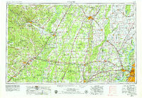
~ Memphis TN topo map, 1:250000 scale, 1 X 2 Degree, Historical, 1953, updated 1979
Memphis, Tennessee, USGS topographic map dated 1953.
Includes geographic coordinates (latitude and longitude). This topographic map is suitable for hiking, camping, and exploring, or framing it as a wall map.
Printed on-demand using high resolution imagery, on heavy weight and acid free paper, or alternatively on a variety of synthetic materials.
Topos available on paper, Waterproof, Poly, or Tyvek. Usually shipping rolled, unless combined with other folded maps in one order.
- Product Number: USGS-5339242
- Free digital map download (high-resolution, GeoPDF): Memphis, Tennessee (file size: 16 MB)
- Map Size: please refer to the dimensions of the GeoPDF map above
- Weight (paper map): ca. 55 grams
- Map Type: POD USGS Topographic Map
- Map Series: HTMC
- Map Verison: Historical
- Cell ID: 68906
- Scan ID: 150040
- Imprint Year: 1979
- Woodland Tint: Yes
- Photo Revision Year: 1978
- Aerial Photo Year: 1976
- Edit Year: 1978
- Field Check Year: 1953
- Datum: Unstated
- Map Projection: Transverse Mercator
- Map published by United States Geological Survey
- Map Language: English
- Scanner Resolution: 600 dpi
- Map Cell Name: Memphis
- Grid size: 1 X 2 Degree
- Date on map: 1953
- Map Scale: 1:250000
- Geographical region: Tennessee, United States
Neighboring Maps:
All neighboring USGS topo maps are available for sale online at a variety of scales.
Spatial coverage:
Topo map Memphis, Tennessee, covers the geographical area associated the following places:
- Rogers Addition - Beard (historical) - Almont (historical) - Tyronza Junction - Fair Oaks - Three Forks - Sandy - McDaniel - Cash - Stier - Bondsville - Fitzhugh - Meneshea - Antioch - Pumpkin Bend - Rosemary Lane - Redman Point - Bethesda - Walnut Grove Corner - Stringers Mill - Georgetown - Shady Grove - McCrory - Mountain Home - Augusta - Dixie Homes - Pleasant Grove - Lockheart (historical) - Cedar Grove - Grubbs - Welford (historical) - Clear Water (historical) - Russell - Carmi - Cow Lake (historical) - Mooresville (historical) - Brushey Lake - Bay - Darwin - Roy - Mount Vernon (historical) - Wiley Crossing - Simsboro - Dixie - Beebe - Carr (historical) - Diaz - Floral - Campbell Station - Birdsong - Union - Black Cat - Penters Bluff (historical) - Ramsey - Bald Knob - Engman (historical) - Higginson - Barber (historical) - Lunsford - March (historical) - Rugby - Melrose - Whitburg (historical) - Moorefield - Sulphur Rock - Waldenburg - Wiville - Desha - Midway - Amith Addition - Daggett - Harmony - Budsmith (historical) - McGregor - Farrville - Uno - Old Grand Glaise - Cunningham Corner - Chalybeate Springs - Keeler Corner - McElroy - Negro Head Corner - Bradford - Jericho - Benjestown - Cedar Grove - Whitehall - Driver - Heafer - Caldwell - Fitzgerald Crossing - Burnt Hill - Conant - Morning Sun - Lost Cane - Fisher - Pace - Grassy Lake Bottom - Broom (historical) - Yarbo Place
- Map Area ID: AREA3635-92-90
- Northwest corner Lat/Long code: USGSNW36-92
- Northeast corner Lat/Long code: USGSNE36-90
- Southwest corner Lat/Long code: USGSSW35-92
- Southeast corner Lat/Long code: USGSSE35-90
- Northern map edge Latitude: 36
- Southern map edge Latitude: 35
- Western map edge Longitude: -92
- Eastern map edge Longitude: -90


