
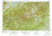
~ Knoxville TN topo map, 1:250000 scale, 1 X 2 Degree, Historical, 1957, updated 1974
Knoxville, Tennessee, USGS topographic map dated 1957.
Includes geographic coordinates (latitude and longitude). This topographic map is suitable for hiking, camping, and exploring, or framing it as a wall map.
Printed on-demand using high resolution imagery, on heavy weight and acid free paper, or alternatively on a variety of synthetic materials.
Topos available on paper, Waterproof, Poly, or Tyvek. Usually shipping rolled, unless combined with other folded maps in one order.
- Product Number: USGS-5339238
- Free digital map download (high-resolution, GeoPDF): Knoxville, Tennessee (file size: 25 MB)
- Map Size: please refer to the dimensions of the GeoPDF map above
- Weight (paper map): ca. 55 grams
- Map Type: POD USGS Topographic Map
- Map Series: HTMC
- Map Verison: Historical
- Cell ID: 68859
- Scan ID: 148018
- Imprint Year: 1974
- Woodland Tint: Yes
- Visual Version Number: 1
- Photo Revision Year: 1972
- Aerial Photo Year: 1971
- Edit Year: 1972
- Field Check Year: 1957
- Datum: Unstated
- Map Projection: Transverse Mercator
- Map published by United States Geological Survey
- Map published by: Military, Other
- Map Language: English
- Scanner Resolution: 600 dpi
- Map Cell Name: Knoxville
- Grid size: 1 X 2 Degree
- Date on map: 1957
- Map Scale: 1:250000
- Geographical region: Tennessee, United States
Neighboring Maps:
All neighboring USGS topo maps are available for sale online at a variety of scales.
Spatial coverage:
Topo map Knoxville, Tennessee, covers the geographical area associated the following places:
- Unaka Station (historical) - Collinsville - Bassel Addition - Gibson Acres Mobile Home Park - Kingswood - Graphite - Ruby City - Maple Springs - Worley - Glenmore Estates - Terry Fork - Fingerville - Topton - Emerald Hills Estates - Buckner - Proctor - Shumont - Iotla - Oakland - Lake Junaluska - Orlando - Hillandale - Clark Estates - Lickskillet - Union Hill - Owltown - Hornet - Powder Springs (historical) - Broadview Estates - Westwood Hills - Wattacoo (historical) - Fairfield Mountains - Merrittsville (historical) - Beaverdam - Beechertown - Blossomtown - Hayesville - Mitchell (historical) - Spring Time - Leatherman - Dillsboro - Briarcliff - Nough - Nanney (historical) - Tuxedo - Sunnyvale - Meades Quarry - Lee Walker Hots - Echo Hills - Pleasant Hill - Sapphire - Stony Fork - Wolf Ridge - Shaleville - Stone Brook - Elkmont - Tuscola Park - Vose - Berry Mill - Cherryfield - Needmore - Jenkins Meadow - Pine Grove - East Fork - Druid Hills - Sunset View - Erastus - Holly Springs - Walkertown - Lakemont - Lynch (historical) - Valley View Vistas - Spruce Pine - Micaville - Stoneycrest - Oxford Hills - Raven Branch - Woodrow - Golf Estates - Sunshine - Day Book - Town Forest - Zion Grove - Woodhaven - Clark - Fernwood - Welwyn (historical) - Unahala - Pleasant Grove - Tuckaleechee - Azalea - Center Pigeon - Willow Bend - Runion - Bailey Town - Elk Shoal - Carolina Village - Cullowhee - Ravenwood - Cane Brake
- Map Area ID: AREA3635-84-82
- Northwest corner Lat/Long code: USGSNW36-84
- Northeast corner Lat/Long code: USGSNE36-82
- Southwest corner Lat/Long code: USGSSW35-84
- Southeast corner Lat/Long code: USGSSE35-82
- Northern map edge Latitude: 36
- Southern map edge Latitude: 35
- Western map edge Longitude: -84
- Eastern map edge Longitude: -82


