
~ Knoxville TN topo map, 1:250000 scale, 1 X 2 Degree, Historical, 1955
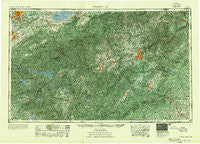
Knoxville, Tennessee, USGS topographic map dated 1955.
Includes geographic coordinates (latitude and longitude). This topographic map is suitable for hiking, camping, and exploring, or framing it as a wall map.
Printed on-demand using high resolution imagery, on heavy weight and acid free paper, or alternatively on a variety of synthetic materials.
Topos available on paper, Waterproof, Poly, or Tyvek. Usually shipping rolled, unless combined with other folded maps in one order.
- Product Number: USGS-5339226
- Free digital map download (high-resolution, GeoPDF): Knoxville, Tennessee (file size: 26 MB)
- Map Size: please refer to the dimensions of the GeoPDF map above
- Weight (paper map): ca. 55 grams
- Map Type: POD USGS Topographic Map
- Map Series: HTMC
- Map Verison: Historical
- Cell ID: 68859
- Scan ID: 148012
- Woodland Tint: Yes
- Aerial Photo Year: 1952
- Field Check Year: 1953
- Datum: NAD27
- Map Projection: Polyconic
- Map published by United States Army Corps of Engineers
- Map published by United States Army
- Map Language: English
- Scanner Resolution: 600 dpi
- Map Cell Name: Knoxville
- Grid size: 1 X 2 Degree
- Date on map: 1955
- Map Scale: 1:250000
- Geographical region: Tennessee, United States
Neighboring Maps:
All neighboring USGS topo maps are available for sale online at a variety of scales.
Spatial coverage:
Topo map Knoxville, Tennessee, covers the geographical area associated the following places:
- Baxter - Guntertown - Blue Rock - Wildwood - Andy Cove - Shady Grove - Esmeralda (historical) - Dellwood - Jordan - Long Creek - Lakeview Estates - Gneiss - Tumblerville - Golf Estates - Laurel Park - Powder Springs (historical) - Swannanoa Hills - Hamilton Estates - Lonsdale - Catheys Creek Estates - Mountain Trace - Hardin - Coburn - Inman - Melrose - Ola - Evergreen Pointe Mobile Home Park - Windor Hills - Fleetwood Estates - Teresita - Middle Creek - Dana - Bear Creek - Riverdale - Wilsonville - Roundhill - Chapel Hill - Hatchertown - Mule Hollow - Woodland Hills - Marbledale - Riverview - Blossomtown - Shady Grove - Jeter Mountain Terrace - Lakewood - Cherokee - Plantation Walk - Stony Fork - Sweetgum - Sunset View - East Fork - Turkey Pen Gap - Ravenwood - Erastus - Lonas Addition - Wilmot - Rivertrace - Gap Creek - Ravensford - Stackhouse - Marietta - Royal Pines - Buffalo - Bent Tree - Hayesville - Shooks - Blue Ridge Overlook - Shaleville - Tidmans Place - Gay - Beulah - Forks of the River - Whittier - Woodmont Addition - Edwina - Fingerville - Cosby - Morning Star - East Springbrook - Ewing (historical) - Stoney Knob - Sherwood Forest - Millican Grove - Neubert Springs - Oldtown - Slater - Knob Creek - Revere - Blantyre - Cuba (historical) - Little River - Sunburst - Highland Acres - Gibsontown - Locust Hill - Seaton - Milltown - Oak City - Chanteloupe Country Estates
- Map Area ID: AREA3635-84-82
- Northwest corner Lat/Long code: USGSNW36-84
- Northeast corner Lat/Long code: USGSNE36-82
- Southwest corner Lat/Long code: USGSSW35-84
- Southeast corner Lat/Long code: USGSSE35-82
- Northern map edge Latitude: 36
- Southern map edge Latitude: 35
- Western map edge Longitude: -84
- Eastern map edge Longitude: -82


