
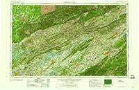
~ Johnson City TN topo map, 1:250000 scale, 1 X 2 Degree, Historical, 1960
Johnson City, Tennessee, USGS topographic map dated 1960.
Includes geographic coordinates (latitude and longitude). This topographic map is suitable for hiking, camping, and exploring, or framing it as a wall map.
Printed on-demand using high resolution imagery, on heavy weight and acid free paper, or alternatively on a variety of synthetic materials.
Topos available on paper, Waterproof, Poly, or Tyvek. Usually shipping rolled, unless combined with other folded maps in one order.
- Product Number: USGS-5339222
- Free digital map download (high-resolution, GeoPDF): Johnson City, Tennessee (file size: 23 MB)
- Map Size: please refer to the dimensions of the GeoPDF map above
- Weight (paper map): ca. 55 grams
- Map Type: POD USGS Topographic Map
- Map Series: HTMC
- Map Verison: Historical
- Cell ID: 68844
- Scan ID: 148010
- Woodland Tint: Yes
- Datum: Unstated
- Map Projection: Transverse Mercator
- Map published by United States Army Corps of Engineers
- Map published by United States Army
- Map Language: English
- Scanner Resolution: 600 dpi
- Map Cell Name: Johnson City
- Grid size: 1 X 2 Degree
- Date on map: 1960
- Map Scale: 1:250000
- Geographical region: Tennessee, United States
Neighboring Maps:
All neighboring USGS topo maps are available for sale online at a variety of scales.
Spatial coverage:
Topo map Johnson City, Tennessee, covers the geographical area associated the following places:
- Bald Crossing - Three Points - Morrison City - Lake Park - Rock Creek - Timber Line Estates - Brentwood - Hales Crossroads - Napier - Ridgefields - Riverview - Beacon Hills - Wood - Nances Grove - Virginia City - Lano - Carmen - Bardo - Ottway - Kittyton (historical) - Rhodelia (historical) - Sevier Terrace - Middlesboro - Sulphur Springs - Dona - Kansas City - Manring - Clover - Gate City - Haversons (historical) - Rayon Terrace - Ridgeview Mobile Home Park - Cedar Hills - Double Springs - Premier - Jefferson City - Snodgrass - Riverview - Williams Mill - Love Station - High Health (historical) - Gabe (historical) - Holston (historical) - Pondtown - Sulphur Springs - Dooley - Brotherton - Colliers Corner - Craft Spring - Gap Creek - Hillrise - Clinchview Heights - Mockingbird Mobile Home Park - Oak Park - Sampson - Keokee - Clear Springs (historical) - Three Mountains - Little Barren - Red Hill - Needmore - Russell Mill - Kimbrough Crossroad - Broylesville - Roe - Little Barren - Lyonton - Ramsey - Loveland - Horace (historical) - Hilander Park - Pineville - Lucilla (historical) - Harbison Crossroads - Ottinger - Mountain View - Smiley - Evarts - Cracker Neck - Whitson - Collinwood - Parsonage - Cedar Grove - Riovista - Caswell - Nash Ford - Mitchell Springs - Beechnut Subdivision - Grays Ford - Bonny Blue - Ashby (historical) - Stokes Mill - Tampico - Ben Hur - Tazewell - Piedmont - Winner - Rex - Fuller Estates - Holston View
- Map Area ID: AREA3736-84-82
- Northwest corner Lat/Long code: USGSNW37-84
- Northeast corner Lat/Long code: USGSNE37-82
- Southwest corner Lat/Long code: USGSSW36-84
- Southeast corner Lat/Long code: USGSSE36-82
- Northern map edge Latitude: 37
- Southern map edge Latitude: 36
- Western map edge Longitude: -84
- Eastern map edge Longitude: -82


