
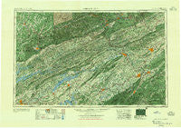
~ Johnson City TN topo map, 1:250000 scale, 1 X 2 Degree, Historical, 1955
Johnson City, Tennessee, USGS topographic map dated 1955.
Includes geographic coordinates (latitude and longitude). This topographic map is suitable for hiking, camping, and exploring, or framing it as a wall map.
Printed on-demand using high resolution imagery, on heavy weight and acid free paper, or alternatively on a variety of synthetic materials.
Topos available on paper, Waterproof, Poly, or Tyvek. Usually shipping rolled, unless combined with other folded maps in one order.
- Product Number: USGS-5339218
- Free digital map download (high-resolution, GeoPDF): Johnson City, Tennessee (file size: 25 MB)
- Map Size: please refer to the dimensions of the GeoPDF map above
- Weight (paper map): ca. 55 grams
- Map Type: POD USGS Topographic Map
- Map Series: HTMC
- Map Verison: Historical
- Cell ID: 68844
- Scan ID: 148008
- Woodland Tint: Yes
- Datum: Unstated
- Map Projection: Transverse Mercator
- Map published by United States Army Corps of Engineers
- Map published by United States Army
- Map Language: English
- Scanner Resolution: 600 dpi
- Map Cell Name: Johnson City
- Grid size: 1 X 2 Degree
- Date on map: 1955
- Map Scale: 1:250000
- Geographical region: Tennessee, United States
Neighboring Maps:
All neighboring USGS topo maps are available for sale online at a variety of scales.
Spatial coverage:
Topo map Johnson City, Tennessee, covers the geographical area associated the following places:
- Riovista - Kincheloe (historical) - Brownlow (historical) - McMillan - Field - Eastview - Upper Laurel Fork (historical) - Caswell - Homestead - Arlington - Cadet - Cox Mill - Bluegrass - Vicco - Perrin Hollow - Rush Corner - Lakeshore Estates - Treadway - Dooley - Preston Hills - Mendota - Fults Trailer Park - Cranes Nest - Yount Town - Upchurch - Pierce - Seminary - East Park - Sumpter (historical) - Cedar Hill Park - Dotsontown - Foxxborough - Otes - Starnes (historical) - Plato - Sunny Brook - Rambling Hills - Stoney Fork - Cold Springs - Jonesborough - Lynch - Holston View - Allenbridge (historical) - Wahoo (historical) - Holston Heights - Matuta (historical) - Trosper - Central - Cupp Mill - Britton Acres - Bloomingdale - Caney Branch - Mayflower - Virginia Hills - Navaho Hills - Towne Acres - Beans - Boone Heights - Prima Estates - Monte Vista Estates - Eastwood - Pump Springs Mobile Home Park - Fall Creek - Marlyn Hills - Tunbridge - Keith - Timberlake - Sunset Acres - Shenandoah Heights - Counts - Three Points - Holmes - Westgate - Saddle Ridge - Poplar - Helton - Roaring Springs - Belmont Acres - Greendale - Oakland Gardens - Kingsley Hills - Erose - Timber Ridge - Okolona Estates - Dewitt - Dover - Oak Grove - Holiday Hills - Upper Shell Creek - Powell Valley - North Brook - Girlton (historical) - Melrose - Fair Acres - Lost Cove - Wallsend - Pocket - Lake View Park - Westivew Woods - Bethany
- Map Area ID: AREA3736-84-82
- Northwest corner Lat/Long code: USGSNW37-84
- Northeast corner Lat/Long code: USGSNE37-82
- Southwest corner Lat/Long code: USGSSW36-84
- Southeast corner Lat/Long code: USGSSE36-82
- Northern map edge Latitude: 37
- Southern map edge Latitude: 36
- Western map edge Longitude: -84
- Eastern map edge Longitude: -82


