
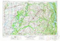
~ Dyersburg TN topo map, 1:250000 scale, 1 X 2 Degree, Historical, 1956, updated 1973
Dyersburg, Tennessee, USGS topographic map dated 1956.
Includes geographic coordinates (latitude and longitude). This topographic map is suitable for hiking, camping, and exploring, or framing it as a wall map.
Printed on-demand using high resolution imagery, on heavy weight and acid free paper, or alternatively on a variety of synthetic materials.
Topos available on paper, Waterproof, Poly, or Tyvek. Usually shipping rolled, unless combined with other folded maps in one order.
- Product Number: USGS-5339216
- Free digital map download (high-resolution, GeoPDF): Dyersburg, Tennessee (file size: 17 MB)
- Map Size: please refer to the dimensions of the GeoPDF map above
- Weight (paper map): ca. 55 grams
- Map Type: POD USGS Topographic Map
- Map Series: HTMC
- Map Verison: Historical
- Cell ID: 68760
- Scan ID: 148007
- Imprint Year: 1973
- Woodland Tint: Yes
- Visual Version Number: 1
- Photo Revision Year: 1970
- Aerial Photo Year: 1952
- Edit Year: 1970
- Field Check Year: 1956
- Datum: Unstated
- Map Projection: Transverse Mercator
- Map published by United States Geological Survey
- Map Language: English
- Scanner Resolution: 600 dpi
- Map Cell Name: Dyersburg
- Grid size: 1 X 2 Degree
- Date on map: 1956
- Map Scale: 1:250000
- Geographical region: Tennessee, United States
Neighboring Maps:
All neighboring USGS topo maps are available for sale online at a variety of scales.
Spatial coverage:
Topo map Dyersburg, Tennessee, covers the geographical area associated the following places:
- Liberty - Kimery - Camp Ground - Wynnburg - Penermon - Hall (historical) - Sawyers Mill - Hamlet (historical) - Owl City - Eva Subdivision - Mills Subdivision - Center Ridge (historical) - Lilbourn - Bethel - Nordlow (historical) - Carlston - Dunn - Draffenville - Red Hill - Cunningham - Stone (historical) - Springville - Middle City - Friendship - Moss (historical) - Dogtown - East Lake - Fuget - Phillippy - Briensburg - Brownsville - Mabel - Rushs Ridge - Zion (historical) - Indian Mound - Stubblefield - Tatumville - Fairview - Mount Carmel (historical) - Miller - Townley - Walnut Log - Delmo - Harris Grove - Gardner - Lone Oak (historical) - Lapata - Lick Creek - Portageville - New Markham - Lassiter Corner - Trimble - Harris Hill Ford - Farmington - Pine Point Subdivision - Pinhook - Geveden - Channel - Hancock - Bradleytown - Baxter - Aurora - Locust Grove (historical) - Idalia - Holly Leaf - Union Ridge (historical) - Hermondale - Hayward - Wolverine - Zeta (historical) - Zoar (historical) - Braggadocio - Midway - Charleston - Hurricane Ridge - Oak Grove - Caruthersville - Union City - Claud (historical) - Miner - Blakely (historical) - Conyersville - Cunningham - Avert - Utterback (historical) - Glissonville - Hayti Heights - Vanduser - Hickory Grove (historical) - Golden Pond - Diehlstadt - North Lilbourn - Manleyville - Fairbanks - Whitlock - New Concord - Iola - Wingo - East Prairie - Heloise
- Map Area ID: AREA3736-90-88
- Northwest corner Lat/Long code: USGSNW37-90
- Northeast corner Lat/Long code: USGSNE37-88
- Southwest corner Lat/Long code: USGSSW36-90
- Southeast corner Lat/Long code: USGSSE36-88
- Northern map edge Latitude: 37
- Southern map edge Latitude: 36
- Western map edge Longitude: -90
- Eastern map edge Longitude: -88


