
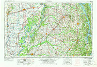
~ Dyersburg TN topo map, 1:250000 scale, 1 X 2 Degree, Historical, 1956, updated 1973
Dyersburg, Tennessee, USGS topographic map dated 1956.
Includes geographic coordinates (latitude and longitude). This topographic map is suitable for hiking, camping, and exploring, or framing it as a wall map.
Printed on-demand using high resolution imagery, on heavy weight and acid free paper, or alternatively on a variety of synthetic materials.
Topos available on paper, Waterproof, Poly, or Tyvek. Usually shipping rolled, unless combined with other folded maps in one order.
- Product Number: USGS-5339214
- Free digital map download (high-resolution, GeoPDF): Dyersburg, Tennessee (file size: 16 MB)
- Map Size: please refer to the dimensions of the GeoPDF map above
- Weight (paper map): ca. 55 grams
- Map Type: POD USGS Topographic Map
- Map Series: HTMC
- Map Verison: Historical
- Cell ID: 68760
- Scan ID: 148006
- Imprint Year: 1973
- Woodland Tint: Yes
- Visual Version Number: 2
- Photo Revision Year: 1970
- Aerial Photo Year: 1952
- Edit Year: 1970
- Field Check Year: 1956
- Datum: Unstated
- Map Projection: Transverse Mercator
- Map published by: Military, Other
- Map Language: English
- Scanner Resolution: 600 dpi
- Map Cell Name: Dyersburg
- Grid size: 1 X 2 Degree
- Date on map: 1956
- Map Scale: 1:250000
- Geographical region: Tennessee, United States
Neighboring Maps:
All neighboring USGS topo maps are available for sale online at a variety of scales.
Spatial coverage:
Topo map Dyersburg, Tennessee, covers the geographical area associated the following places:
- Thirtyfour Corner - Heloise - Claud (historical) - Fenton - Yopp - Harmony (historical) - Huntingdon - Netherlands - Hayward - Oak Hill - Bradford - Shofner - Beech Grove (historical) - Old Fremont - Pisgah - Outland (historical) - Glendale - Nobles - Coldwater - Stella - Oak Ridge - Poplar Grove - Old Shawnee Village (historical) - Oak Wood Estates - Blue Bank - Sherwood Shores - Fancy Farm - Hayti - New Zion - Five Points - East Prairie - Bishop - West Hermondale - Broadmoor - Yorkville - Spoonerville - Matthews - Hinkledale - Buena Vista (historical) - Dodds - Cooter - New Chapel (historical) - Ristine - Payne - Alfalfa Center - Mount Moriah - Millsfield - Como - Lenox - Conyersville - Homestown - Scott - Eva - Old Salem (historical) - Four Points - Trezevant - Hico - Brundige - Dogwood - Fulton - McCruiston (historical) - Arlington - Clayton - Sandy Bridge (historical) - Bryans Ford - Sedalia - Grizzard - Wrightsville - Dexter - Pleasant Hill - North Murray - Wolf Island - Burgess - Sikeston - Chickasaw Heights - Aquilla - Caruthersville - Marston - Rumsey Spur (historical) - Blooming Grove - Richwoods - Palestine - Oakland - Eagle Hill - Roper - Baxter - Spring Hill - Yama - Gidson - Enon - Russell Chapel (historical) - Bethel - RoEllen - Locust Grove - Feliciana - Walnut Grove - Buena Vista - Vale - New Cypress - Browns
- Map Area ID: AREA3736-90-88
- Northwest corner Lat/Long code: USGSNW37-90
- Northeast corner Lat/Long code: USGSNE37-88
- Southwest corner Lat/Long code: USGSSW36-90
- Southeast corner Lat/Long code: USGSSE36-88
- Northern map edge Latitude: 37
- Southern map edge Latitude: 36
- Western map edge Longitude: -90
- Eastern map edge Longitude: -88


