
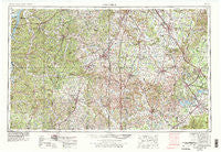
~ Columbia TN topo map, 1:250000 scale, 1 X 2 Degree, Historical, 1956, updated 1979
Columbia, Tennessee, USGS topographic map dated 1956.
Includes geographic coordinates (latitude and longitude). This topographic map is suitable for hiking, camping, and exploring, or framing it as a wall map.
Printed on-demand using high resolution imagery, on heavy weight and acid free paper, or alternatively on a variety of synthetic materials.
Topos available on paper, Waterproof, Poly, or Tyvek. Usually shipping rolled, unless combined with other folded maps in one order.
- Product Number: USGS-5339208
- Free digital map download (high-resolution, GeoPDF): Columbia, Tennessee (file size: 21 MB)
- Map Size: please refer to the dimensions of the GeoPDF map above
- Weight (paper map): ca. 55 grams
- Map Type: POD USGS Topographic Map
- Map Series: HTMC
- Map Verison: Historical
- Cell ID: 68726
- Scan ID: 149591
- Imprint Year: 1979
- Woodland Tint: Yes
- Visual Version Number: 2
- Photo Revision Year: 1978
- Aerial Photo Year: 1976
- Edit Year: 1978
- Field Check Year: 1956
- Datum: Unstated
- Map Projection: Transverse Mercator
- Map published by United States Geological Survey
- Map Language: English
- Scanner Resolution: 600 dpi
- Map Cell Name: Columbia
- Grid size: 1 X 2 Degree
- Date on map: 1956
- Map Scale: 1:250000
- Geographical region: Tennessee, United States
Neighboring Maps:
All neighboring USGS topo maps are available for sale online at a variety of scales.
Spatial coverage:
Topo map Columbia, Tennessee, covers the geographical area associated the following places:
- Fudgearound - Three Forks - Green River (historical) - Harpeth Hills - Halls Mill - Sheybogan - Oak Hill - Paschal Estates - Flatwoods - Fikes Mill - College Grove - Pleasant Grove - Beale (historical) - Wrigley - Chartersville - Flemingsburg (historical) - Bivens - Match - Stringtown - Scribner - Blooming Grove - Cedar Grove - Windrow - Arrington - Taylorsville - Crescent View - Milton - Glaze - Venable Spring - Metal Ford - Pioneer Estates - Cowden - Longview Subdivision - Crossroads - Kraus (historical) - Delina - Blue Creek - West Meade - Concord Forest - Estes Acres - Camargo - Creekwood - Wikles (historical) - Merrit Mobile Village - Brooksville (historical) - Halls Hill - Deerfield - Country Park - Lesters - Mooney - Overall Acres - Pottsville - Anderson - New Herman - Mount Tema - New Era (historical) - Ben (historical) - Dillton - Spencer Creek Place - Henryville - Deerfield - Gum Road Subdivision - Mount Herman - Hollywood - Arno - Robinson (historical) - Brownview Acres - Leoma - Crewstown - Lovetown - Lego (historical) - Hillwood Acres - Teal (historical) - Pearl City - Toms Creek (historical) - Gant - Barfield - Cypress Inn - Culpepper - Bigby (historical) - Old Town (historical) - Riverside - Fieldcrest - Upper Holly Creek - Blue Sky - Canaan - Elora - Walkersville (historical) - Red Hill - Hilltop - Lakeview Estates - Hardwick Subdivision - Emmitt Heights - Himesville - Pleasant View - Creson - Egam - River Club Estates - Triune - Kedron
- Map Area ID: AREA3635-88-86
- Northwest corner Lat/Long code: USGSNW36-88
- Northeast corner Lat/Long code: USGSNE36-86
- Southwest corner Lat/Long code: USGSSW35-88
- Southeast corner Lat/Long code: USGSSE35-86
- Northern map edge Latitude: 36
- Southern map edge Latitude: 35
- Western map edge Longitude: -88
- Eastern map edge Longitude: -86


