
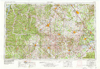
~ Columbia TN topo map, 1:250000 scale, 1 X 2 Degree, Historical, 1956, updated 1979
Columbia, Tennessee, USGS topographic map dated 1956.
Includes geographic coordinates (latitude and longitude). This topographic map is suitable for hiking, camping, and exploring, or framing it as a wall map.
Printed on-demand using high resolution imagery, on heavy weight and acid free paper, or alternatively on a variety of synthetic materials.
Topos available on paper, Waterproof, Poly, or Tyvek. Usually shipping rolled, unless combined with other folded maps in one order.
- Product Number: USGS-5339206
- Free digital map download (high-resolution, GeoPDF): Columbia, Tennessee (file size: 21 MB)
- Map Size: please refer to the dimensions of the GeoPDF map above
- Weight (paper map): ca. 55 grams
- Map Type: POD USGS Topographic Map
- Map Series: HTMC
- Map Verison: Historical
- Cell ID: 68726
- Scan ID: 149590
- Imprint Year: 1979
- Woodland Tint: Yes
- Photo Revision Year: 1978
- Aerial Photo Year: 1976
- Edit Year: 1978
- Field Check Year: 1956
- Datum: Unstated
- Map Projection: Transverse Mercator
- Map published by United States Geological Survey
- Map Language: English
- Scanner Resolution: 600 dpi
- Map Cell Name: Columbia
- Grid size: 1 X 2 Degree
- Date on map: 1956
- Map Scale: 1:250000
- Geographical region: Tennessee, United States
Neighboring Maps:
All neighboring USGS topo maps are available for sale online at a variety of scales.
Spatial coverage:
Topo map Columbia, Tennessee, covers the geographical area associated the following places:
- Ridgecrest Acres - Richardson (historical) - Anthony Hill - Falls Mill - Cumberland Springs - Ewingville - Stout - Marcella (historical) - West Meade - Bobs Cross Roads (historical) - Strauss Mill - Hillwood Acres - Vanntown - Lickskillet (historical) - Bradshaw - Mill Seat - Riversburg - Lower Elkton (historical) - Westwood - Red Hill - Baugh - Oak Tree - Graham - New Antwerp (historical) - Barfield Meadows - Voorhies - Bivens - Lower Mockeson - Hensley Ridge (historical) - Brentwood Hills - Trinity - Hendersons Subdivision - Seth - Mount Nebo - Brown Crossroads - Swan Bluff - Scenic Heights - Kittrell Heights - Parry - Vannatta - Oak Grove - Graymere Manor - Ewingsville (historical) - Compton Meadows - Salem - Asia - Lake Farm Estates - Bryant Station - Wills (historical) - Burwood - Springer Ridge (historical) - Holly (historical) - Esquire Estates - Richmond - Fikes Mill - Mount Carmel - Ovoca - Howard (historical) - Walnut Grove - Gaitherville - Forrest Park - Liberty Hill - Poplar Grove - Rebel Acres - Forest Home - Burgen - Riverwood - Callie - Petersburg - Mayberry (historical) - Oak Hill - Hughey - Lascassas - Duplex Mission - Forest Home Farms - Twin Springs Estates - Crescent - Belmont - Whitehouse - Glendale - Mowd (historical) - Two Hills - Yell - Sims Ridge - Crestview - Gethsemane (historical) - Highland Rim Falls Subdivision - Penile Hill - Aymett Town - Anderson - Fudgearound - Rich - Double Springs - Beans Creek - Cedar Grove - Jamestown - New Hope - Concord (historical) - Sugar Hill - Sharon Park
- Map Area ID: AREA3635-88-86
- Northwest corner Lat/Long code: USGSNW36-88
- Northeast corner Lat/Long code: USGSNE36-86
- Southwest corner Lat/Long code: USGSSW35-88
- Southeast corner Lat/Long code: USGSSE35-86
- Northern map edge Latitude: 36
- Southern map edge Latitude: 35
- Western map edge Longitude: -88
- Eastern map edge Longitude: -86


