
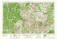
~ Columbia TN topo map, 1:250000 scale, 1 X 2 Degree, Historical, 1956, updated 1967
Columbia, Tennessee, USGS topographic map dated 1956.
Includes geographic coordinates (latitude and longitude). This topographic map is suitable for hiking, camping, and exploring, or framing it as a wall map.
Printed on-demand using high resolution imagery, on heavy weight and acid free paper, or alternatively on a variety of synthetic materials.
Topos available on paper, Waterproof, Poly, or Tyvek. Usually shipping rolled, unless combined with other folded maps in one order.
- Product Number: USGS-5339202
- Free digital map download (high-resolution, GeoPDF): Columbia, Tennessee (file size: 19 MB)
- Map Size: please refer to the dimensions of the GeoPDF map above
- Weight (paper map): ca. 55 grams
- Map Type: POD USGS Topographic Map
- Map Series: HTMC
- Map Verison: Historical
- Cell ID: 68726
- Scan ID: 149586
- Imprint Year: 1967
- Woodland Tint: Yes
- Edit Year: 1966
- Field Check Year: 1956
- Datum: Unstated
- Map Projection: Transverse Mercator
- Map published by United States Geological Survey
- Map Language: English
- Scanner Resolution: 600 dpi
- Map Cell Name: Columbia
- Grid size: 1 X 2 Degree
- Date on map: 1956
- Map Scale: 1:250000
- Geographical region: Tennessee, United States
Neighboring Maps:
All neighboring USGS topo maps are available for sale online at a variety of scales.
Spatial coverage:
Topo map Columbia, Tennessee, covers the geographical area associated the following places:
- Zion - Brian Manor - Chestnut Hill - Fairview - Haynes Haven - Branchville - Shiloh - Dunn - Benton (historical) - Cumberland Springs - Chapel Hill - Hillwood Acres - Red Hill - Powell Chapel - Cateston - Westside Heights - Countyline - Delina - Big Creek - Pleasantville - Jernigan (historical) - Hardscrabble - Brooksville (historical) - Readyville - Unionville - Sumac - Meadowview - Odd Fellows Hall - Joywood - Wikles (historical) - Walter Hill Estates - Verona - Campbells Station - Jamestown - Bon Aqua - Smithland - Blanche - Pleasant Grove - Spencer Creek Place - Creekwood - Bel-Aire - Gum - Hales Camp - Taylorsville - Blackman - Berrys Chapel Heights - Primm Springs - Fly - Center Point - Triune - Screamer - Kimmins - Ostella - Crockett Hills - Moccasin - Sheybogan - Bigby (historical) - Houston - Waco - Match - Cromwell Crossroads - Bugscuffle - Shawnette - Lynchburg - Wills (historical) - Pineview Heights - Bivens - Bond - Wheelerton - Brick Church - Sycamore - Red Hill - Webbs Jungle - Heatherwood Hills - Rally Hill - Duplex - Napier - Theodore - Leanna - Belmont - Lamb - McCains - Duncantown - Hollow Springs - Short Creek - Gattistown - Shadowbrook - Smarden - Cowden - Awalt (historical) - Champ - Porterfield - Millville - Clay Hill - Ridgeville - Old South Estates - Estes Acres - Pleasant Grove - Black Jack - Grassland
- Map Area ID: AREA3635-88-86
- Northwest corner Lat/Long code: USGSNW36-88
- Northeast corner Lat/Long code: USGSNE36-86
- Southwest corner Lat/Long code: USGSSW35-88
- Southeast corner Lat/Long code: USGSSE35-86
- Northern map edge Latitude: 36
- Southern map edge Latitude: 35
- Western map edge Longitude: -88
- Eastern map edge Longitude: -86


