
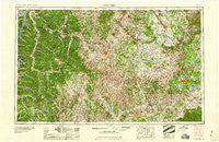
~ Columbia TN topo map, 1:250000 scale, 1 X 2 Degree, Historical, 1956, updated 1960
Columbia, Tennessee, USGS topographic map dated 1956.
Includes geographic coordinates (latitude and longitude). This topographic map is suitable for hiking, camping, and exploring, or framing it as a wall map.
Printed on-demand using high resolution imagery, on heavy weight and acid free paper, or alternatively on a variety of synthetic materials.
Topos available on paper, Waterproof, Poly, or Tyvek. Usually shipping rolled, unless combined with other folded maps in one order.
- Product Number: USGS-5339200
- Free digital map download (high-resolution, GeoPDF): Columbia, Tennessee (file size: 20 MB)
- Map Size: please refer to the dimensions of the GeoPDF map above
- Weight (paper map): ca. 55 grams
- Map Type: POD USGS Topographic Map
- Map Series: HTMC
- Map Verison: Historical
- Cell ID: 68726
- Scan ID: 149585
- Imprint Year: 1960
- Woodland Tint: Yes
- Visual Version Number: 2
- Field Check Year: 1956
- Datum: Unstated
- Map Projection: Transverse Mercator
- Map published by United States Army Corps of Engineers
- Map published by United States Army
- Map Language: English
- Scanner Resolution: 600 dpi
- Map Cell Name: Columbia
- Grid size: 1 X 2 Degree
- Date on map: 1956
- Map Scale: 1:250000
- Geographical region: Tennessee, United States
Neighboring Maps:
All neighboring USGS topo maps are available for sale online at a variety of scales.
Spatial coverage:
Topo map Columbia, Tennessee, covers the geographical area associated the following places:
- East Cyruston - Manus Town (historical) - Mayberry (historical) - Walkersville (historical) - Floraton - Cherry Hill Estates - Taylortown - Kittrell Heights - K C Subdivision - Iron City - Aethra - Royal Oaks - Enterprise - Richardson (historical) - Cheatham (historical) - Union Ridge - Mountain View Acres - Match - Madden Homes - Littlelot - Hilltop - Old Fosterville (historical) - Rucker - Cowan - Ragsdale - Fairview - Wallace Acres - Sorby (historical) - Duncantown - Plainfield Subdivision - Sugar Hill - Shady Acres - Hickory Hills - Columbia Gardens - Boonshill - Pinewood - Dooley (historical) - Scenic Heights - Verona - Beans Creek - Holt - Mooney - Wrigley - Bottle Hollow - Oak Tree - Oakwood - Buffalo - Culleoka - Ellington Park - Leoma - Bel-Aire Heights - Allisona - Southern Hills - Merrit Mobile Village - Lomax Crossroads - Center Star - Mount Vernon - Riverwood - Broadview - Carnton Plantation - Fieldcrest - Thyatira (historical) - Ostella - Shady Grove - Owens (historical) - Meadow Green Acres - Cyclone (historical) - Richmond - Bruner Crossing - Juniper Acres - Lick Creek (historical) - Summertown - Blondy - Pinkney - Oak Hill - Twin Springs Estates - Boyd Mill Estates - Benhill - Auburntown - Mount Olive - Chestnut Ridge - Old South Estates - Red Hill - Sturbridge Pointe - Lanton - Shubert - Gattistown - Link - Carter Crossroads - Liberty Hill - Park Grove - Whitaker - Napier - Neil - Rascal Town - Elkmont Springs - Yates (historical) - Two Hills - Hickory Grove - Monticello
- Map Area ID: AREA3635-88-86
- Northwest corner Lat/Long code: USGSNW36-88
- Northeast corner Lat/Long code: USGSNE36-86
- Southwest corner Lat/Long code: USGSSW35-88
- Southeast corner Lat/Long code: USGSSE35-86
- Northern map edge Latitude: 36
- Southern map edge Latitude: 35
- Western map edge Longitude: -88
- Eastern map edge Longitude: -86


