
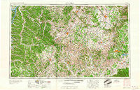
~ Columbia TN topo map, 1:250000 scale, 1 X 2 Degree, Historical, 1956, updated 1960
Columbia, Tennessee, USGS topographic map dated 1956.
Includes geographic coordinates (latitude and longitude). This topographic map is suitable for hiking, camping, and exploring, or framing it as a wall map.
Printed on-demand using high resolution imagery, on heavy weight and acid free paper, or alternatively on a variety of synthetic materials.
Topos available on paper, Waterproof, Poly, or Tyvek. Usually shipping rolled, unless combined with other folded maps in one order.
- Product Number: USGS-5339198
- Free digital map download (high-resolution, GeoPDF): Columbia, Tennessee (file size: 18 MB)
- Map Size: please refer to the dimensions of the GeoPDF map above
- Weight (paper map): ca. 55 grams
- Map Type: POD USGS Topographic Map
- Map Series: HTMC
- Map Verison: Historical
- Cell ID: 68726
- Scan ID: 149584
- Imprint Year: 1960
- Woodland Tint: Yes
- Visual Version Number: 1
- Field Check Year: 1956
- Datum: Unstated
- Map Projection: Transverse Mercator
- Map published by United States Geological Survey
- Map published by United States Army Corps of Engineers
- Map published by United States Army
- Map Language: English
- Scanner Resolution: 600 dpi
- Map Cell Name: Columbia
- Grid size: 1 X 2 Degree
- Date on map: 1956
- Map Scale: 1:250000
- Geographical region: Tennessee, United States
Neighboring Maps:
All neighboring USGS topo maps are available for sale online at a variety of scales.
Spatial coverage:
Topo map Columbia, Tennessee, covers the geographical area associated the following places:
- Milltown - Linden - Caldwell - Wheelerton - Gandy - Dooley (historical) - Pinewood - Brooksville (historical) - Buffalo Valley - Pleasant Grove Subdivision - Saint Truitt - Strauss Mill - Unionville - Winchester Springs - Three Oaks - Springers Station - Pleasant Grove - Fox Camp Meadows - Aspen Hill - Bold Spring - Culpepper - Prosperity - Boxwood Hall - Esquire Estates - Westside Heights - Carrollville (historical) - Booneville - Hallview Meadows - Needmore - Walnut Grove - Spencer Creek Place - Beasley Crossroads - Mount Carmel - Catalpa - Liberty Grove - Franklin - Sharon Park - Yearwood Addition - Williamsburg - Haley - Green River (historical) - Cash Point - Mowd (historical) - Kenny Brook - Brookhill - Broadview - Bates - Whiteoak - Elmwood Terrace - Watson - New Las Casas (historical) - Glaze - Farmington - McKnight - Corder Crossroads - New Prospect - Gossburg - Poplar Hill - Fairview - Oak Tree - Foxridge - Lyles - Flintville - Estes Acres - Oakland (historical) - Buffalo - Siglo - Sage (historical) - Elils Ranch Acres - Belle Mead - Cherry Hill Estates - Grammer Estates - Topsy - Sal City - Bel-Aire - Overall Acres - Walnut Hills - Lomax Crossroads - Glendale - Davis Meadows - Duncantown - Highland Rim Falls Subdivision - Orrs - Hurdlow - Dughill (historical) - Sulphur Springs (historical) - Concord Country Estates - Marble Hill - Southgate Park - Center Point - Twomey - High Point Subdivision - Jernigan Subdivision - Joneswood - Rascal Town - Camargo - Clement Lake Estates - Gant - Shady Grove - West Cyruston
- Map Area ID: AREA3635-88-86
- Northwest corner Lat/Long code: USGSNW36-88
- Northeast corner Lat/Long code: USGSNE36-86
- Southwest corner Lat/Long code: USGSSW35-88
- Southeast corner Lat/Long code: USGSSE35-86
- Northern map edge Latitude: 36
- Southern map edge Latitude: 35
- Western map edge Longitude: -88
- Eastern map edge Longitude: -86


