
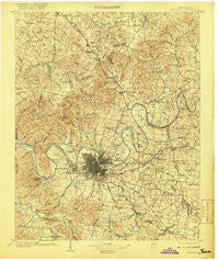
~ Nashville TN topo map, 1:125000 scale, 30 X 30 Minute, Historical, 1903, updated 1918
Nashville, Tennessee, USGS topographic map dated 1903.
Includes geographic coordinates (latitude and longitude). This topographic map is suitable for hiking, camping, and exploring, or framing it as a wall map.
Printed on-demand using high resolution imagery, on heavy weight and acid free paper, or alternatively on a variety of synthetic materials.
Topos available on paper, Waterproof, Poly, or Tyvek. Usually shipping rolled, unless combined with other folded maps in one order.
- Product Number: USGS-5339102
- Free digital map download (high-resolution, GeoPDF): Nashville, Tennessee (file size: 9 MB)
- Map Size: please refer to the dimensions of the GeoPDF map above
- Weight (paper map): ca. 55 grams
- Map Type: POD USGS Topographic Map
- Map Series: HTMC
- Map Verison: Historical
- Cell ID: 65604
- Scan ID: 153480
- Imprint Year: 1918
- Survey Year: 1901
- Datum: Unstated
- Map Projection: Unstated
- Map published by United States Geological Survey
- Map Language: English
- Scanner Resolution: 600 dpi
- Map Cell Name: Greenbrier
- Grid size: 30 X 30 Minute
- Date on map: 1903
- Map Scale: 1:125000
- Geographical region: Tennessee, United States
Neighboring Maps:
All neighboring USGS topo maps are available for sale online at a variety of scales.
Spatial coverage:
Topo map Nashville, Tennessee, covers the geographical area associated the following places:
- Walnut Hills - Pebble Creek - Jimtown (historical) - Joelton - Hillview Estates - Ridgetop - Una - Lynn Christie - Vaughns Gap - Curtiswood - Hygeia Springs - Harpeth Estates - Cloverland Acres - Cumberland Heights - Tusculum - Walnut Hills Estates - Tulip Grove - Cedarbrook - Old Hickory - La Vergne - Hoffasville (historical) - Rolling Acres - Hite (historical) - Oak Hampton - Harbor View - Iroquois Meadows - Monte Carlo Estates - Marvel (historical) - Forest Grove - Langford Cove - Morningside Acres - Gertrude (historical) - Coopertown - Derby Glen - Loveville (historical) - Dekemont Downs - Ivy Point - Maple Row Estates - Curry (historical) - Sarah Berry Annex - Jackson Hollow - Walnut Grove - Lankford Farms - Bakers - Myrtlewood Estates - Paragon Mills - Solitude Acres - Tyree Springs (historical) - Glenview - Devonshire Manor - Heathrow Hills - The Maples - Wrencoe - In-A-Vale-Estates - Indian Lake Forest - Creekmont - Station Camp (historical) - Nonaville - Castlegate Estates - Oakmont - Indian Lake Farms - Bellshire - Beverly Heights - Barclay Square - Millersville - Williams Hills - Bordeaux Hills - Natchez Hills Estate - Longwood - Battlewood Forest - Couchville - Sandhill - Moreland Farms - Eastwood - Harpeth River Estates - Johnsons Crossroads - Berryville - Oakdale - Forest of Brentwood - Raintree Estates - Bakertown - Whites Creek - North Hills Estates - Belle Rive - Glen Oaks - Scottsboro - Charlotte Park - Wilkerson (historical) - Four Corners (historical) - Mudtavern - Lindsley (historical) - Iroquois Estates - Hickory Valley Estates - Sherwood Forest - Cummings Crossroads - Twin Valley - Hidden Valley Estates - Steeple Chase Farms - Greenville - Oakwood Terrace
- Map Area ID: AREA36.536-87-86.5
- Northwest corner Lat/Long code: USGSNW36.5-87
- Northeast corner Lat/Long code: USGSNE36.5-86.5
- Southwest corner Lat/Long code: USGSSW36-87
- Southeast corner Lat/Long code: USGSSE36-86.5
- Northern map edge Latitude: 36.5
- Southern map edge Latitude: 36
- Western map edge Longitude: -87
- Eastern map edge Longitude: -86.5


