
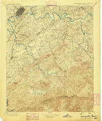
~ Knoxville TN topo map, 1:125000 scale, 30 X 30 Minute, Historical, 1895
Knoxville, Tennessee, USGS topographic map dated 1895.
Includes geographic coordinates (latitude and longitude). This topographic map is suitable for hiking, camping, and exploring, or framing it as a wall map.
Printed on-demand using high resolution imagery, on heavy weight and acid free paper, or alternatively on a variety of synthetic materials.
Topos available on paper, Waterproof, Poly, or Tyvek. Usually shipping rolled, unless combined with other folded maps in one order.
- Product Number: USGS-5339010
- Free digital map download (high-resolution, GeoPDF): Knoxville, Tennessee (file size: 9 MB)
- Map Size: please refer to the dimensions of the GeoPDF map above
- Weight (paper map): ca. 55 grams
- Map Type: POD USGS Topographic Map
- Map Series: HTMC
- Map Verison: Historical
- Cell ID: 320661
- Scan ID: 153456
- Visual Version Number: 2
- Survey Year: 1890
- Datum: Unstated
- Map Projection: Unstated
- Map published by United States Geological Survey
- Map Language: English
- Scanner Resolution: 600 dpi
- Map Cell Name: Knoxville
- Grid size: 30 X 30 Minute
- Date on map: 1895
- Map Scale: 1:125000
- Geographical region: Tennessee, United States
Neighboring Maps:
All neighboring USGS topo maps are available for sale online at a variety of scales.
Spatial coverage:
Topo map Knoxville, Tennessee, covers the geographical area associated the following places:
- Springbrook - Middlebrook Heights - Cowan Springs - Marble City - Mountain Trace - Woodfield Park - Seven Islands - Chilhowee View - Riverbend - Sunshine - Belle Meade - Montvale - Everett Heights - Chelsey Village - Ewing (historical) - Heritage Hills - Montvale Springs - Prospect - Belmont Addition - Scenic Terrace - Little Cove - Marbledale - Mount Nebo (historical) - Beech Springs - Bayview - Topside - Walland - Revilo (historical) - Blount Beach - Oaklawn Addition - Beechwood - Woodmont Addition - Mimosa Estates - Evergreen Pointe Mobile Home Park - Sevier Home - Cusick - Edgewood Acres - Alcoa - Dupont Springs - Knoxville - Stony Point - Pine Grove - Fox Hills - Deep Creek - Eggers Addition - Elajay (historical) - Line Spring - Moshina Heights - Mockingbird Hill - Crossfield - Oak City - Bethel - Middle Creek - Westwood Hills - Greenbrier - Townsend - Providence - Wilham (historical) - Jackson Hills - Gapcreek (historical) - Sunset View - Watertown - Ellejoy - Whites Village - Stock Creek - East Forest - Calderwood - Wimbledon - Glenmore Estates - Huskey Valley - Blockhouse - West View - Cook Mill - Mimosa Heights - Bank (historical) - Hatchertown - Alder Branch - Westfields - Lyons View - Melrose - Cove Creek Cascades - Dupont - Little River - Creekwood - Vestal - Duncan - Yettland Park - Summit Hills - Tara Estates - Notime (historical) - Gatlinburg - Maryville - Cherokee Hills - Seymour - Rockgardens - Lakemoor Hills - Eastover - High Bluff - South View Estates - Newell Station
- Map Area ID: AREA3635.5-84-83.5
- Northwest corner Lat/Long code: USGSNW36-84
- Northeast corner Lat/Long code: USGSNE36-83.5
- Southwest corner Lat/Long code: USGSSW35.5-84
- Southeast corner Lat/Long code: USGSSE35.5-83.5
- Northern map edge Latitude: 36
- Southern map edge Latitude: 35.5
- Western map edge Longitude: -84
- Eastern map edge Longitude: -83.5


