
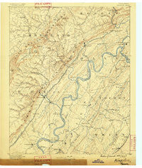
~ Kingston TN topo map, 1:125000 scale, 30 X 30 Minute, Historical, 1887
Kingston, Tennessee, USGS topographic map dated 1887.
Includes geographic coordinates (latitude and longitude). This topographic map is suitable for hiking, camping, and exploring, or framing it as a wall map.
Printed on-demand using high resolution imagery, on heavy weight and acid free paper, or alternatively on a variety of synthetic materials.
Topos available on paper, Waterproof, Poly, or Tyvek. Usually shipping rolled, unless combined with other folded maps in one order.
- Product Number: USGS-5338986
- Free digital map download (high-resolution, GeoPDF): Kingston, Tennessee (file size: 7 MB)
- Map Size: please refer to the dimensions of the GeoPDF map above
- Weight (paper map): ca. 55 grams
- Map Type: POD USGS Topographic Map
- Map Series: HTMC
- Map Verison: Historical
- Cell ID: 65810
- Scan ID: 153445
- Survey Year: 1885
- Datum: Unstated
- Map Projection: Unstated
- Map published by United States Geological Survey
- Map Language: English
- Scanner Resolution: 600 dpi
- Map Cell Name: Kingston
- Grid size: 30 X 30 Minute
- Date on map: 1887
- Map Scale: 1:125000
- Geographical region: Tennessee, United States
Neighboring Maps:
All neighboring USGS topo maps are available for sale online at a variety of scales.
Spatial coverage:
Topo map Kingston, Tennessee, covers the geographical area associated the following places:
- Grassy Cove - Sewee - Lake Shore - Eagle Point Heights - Lake Shadow - Deerwood - Green Acres - King Creek (historical) - Niota - Rogers - Luttrell - Kimbros (historical) - Old Washington - Akeman Crossroad - Mount Zion - Grandview - Boggess Crossroad - Greivertown - Highland Estates - Eagle Furnace - Glen Alice - South Harriman - Webster - Walnut Hill - Culvahouse - Blue Springs - Laurel Bluff - Concord - Maple Grove - Lakeside - Rockwood - Homestead - Millstone - Cedar Fork - Pennine - Acme Mill - New Hope - Lakeharbor - Union Grove - Pond Hill - Fairview - Mount Harmony - Milo - Erie - Ponders - College Grove - Anglers Cove - Windsor Bluff - Oak Hills - Paint Rock - Harriman Junction - Reagan - Alloway - Balta - Eureka - Lakemont Heights - Tranquillity - Hidden Hollow Estates - Cannon Subdivision - Shorewood - Cove Point - Murray Store - Midtown - Shenandoah Estates - Postoak - Bowling - Midtown Heights - Bella Mara Estates - Fiketon - Suburban Shores - Half Moon Shores - Rhea Springs (historical) - Sunnycrest - Lorraine - Apollo Shores - Highland View - Cute (historical) - Dry Hill - Riddles Store - Waldensia - Cumberland Homesteads - Brown Ellis - Decatur Hills - Cook Mill - Pine Grove - Hideaway Hills - Lake Pomeroy - Kemmer Hill - Dorton - Regret (historical) - Bonneville (historical) - Pioneer Village - Marshall Hill - Scott - Eagle Point Cabin Area - Reid Camp - Ozone - Ten Mile - Pine Grove Estates - Bazel Town
- Map Area ID: AREA3635.5-85-84.5
- Northwest corner Lat/Long code: USGSNW36-85
- Northeast corner Lat/Long code: USGSNE36-84.5
- Southwest corner Lat/Long code: USGSSW35.5-85
- Southeast corner Lat/Long code: USGSSE35.5-84.5
- Northern map edge Latitude: 36
- Southern map edge Latitude: 35.5
- Western map edge Longitude: -85
- Eastern map edge Longitude: -84.5


