
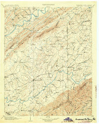
~ Greeneville TN topo map, 1:125000 scale, 30 X 30 Minute, Historical, 1904
Greeneville, Tennessee, USGS topographic map dated 1904.
Includes geographic coordinates (latitude and longitude). This topographic map is suitable for hiking, camping, and exploring, or framing it as a wall map.
Printed on-demand using high resolution imagery, on heavy weight and acid free paper, or alternatively on a variety of synthetic materials.
Topos available on paper, Waterproof, Poly, or Tyvek. Usually shipping rolled, unless combined with other folded maps in one order.
- Product Number: USGS-5338978
- Free digital map download (high-resolution, GeoPDF): Greeneville, Tennessee (file size: 8 MB)
- Map Size: please refer to the dimensions of the GeoPDF map above
- Weight (paper map): ca. 55 grams
- Map Type: POD USGS Topographic Map
- Map Series: HTMC
- Map Verison: Historical
- Cell ID: 65610
- Scan ID: 153442
- Survey Year: 1891
- Datum: Unstated
- Map Projection: Unstated
- Map published by United States Geological Survey
- Map Language: English
- Scanner Resolution: 600 dpi
- Map Cell Name: Greenville
- Grid size: 30 X 30 Minute
- Date on map: 1904
- Map Scale: 1:125000
- Geographical region: Tennessee, United States
Neighboring Maps:
All neighboring USGS topo maps are available for sale online at a variety of scales.
Spatial coverage:
Topo map Greeneville, Tennessee, covers the geographical area associated the following places:
- Chimneytop (historical) - Mountain View Terrace - Washington College - Broylesville - Sunnyside - Henshaw (historical) - Grigsby - Hampton Mill - Stony Point - New Victory - Hickory Hills - Longs Bend - Cloverbottom (historical) - Kendrick Creek (historical) - Harbour - Walter Crossroad - Summer Hills - Union Temple - Spears (historical) - Rocky Fork - Kincheloe Mill - Clearbranch - Williams Subdivision - Craddock Subdivision - Statemount (historical) - Blue Ridge Estates - Petersburg - Saint James - Conkintown - Twin Oaks - Pine Grove - Green Acres - Christie (historical) - Striggersville - College View - Mount Carmel - Chestnut Ridge - Kincheloe (historical) - Bethany - Bright Hope - Woodlawn - Harris Mill - Taylor Acres - Harrison Hills - Derby (historical) - Gilbreath - Mount Pleasant - Summey Subdivision - Briggs (historical) - Mill Brook - Windy Hills - Cedar Hill - Jearoldstown - Ernestville - Rockwood Hill - Wedgewood Hills - College Hills - Woodstone Estates - Alexander Mill - Sullivan Gardens - Tusculum Heights - Bolton Estates - Cedar Lane - Poplar Grove - McDonald Hill - Buckingham Heights - Leming Subdivision - Mount Carmel - Cherrydale - Rheatown - Wheelocktown (historical) - Home Field Terrace - Dykes Mill - Lyons Store (historical) - Gregory Subdivision - Pinecrest - Flag Pond - Graham Mill - Pleasant Valley - Zion Hill - Dotsontown - Blair Gap - Surgoinsville - Lovelace - Castell Springs - Ducktown - Romeo - Slaughter (historical) - Hartmantown - Grandview - Eastview - Oak Hill - Bowmantown - Vogel (historical) - Sirenburg (historical) - Meadowbrook - Craft Spring - Stacy - Van Hill - Adams Mill
- Map Area ID: AREA36.536-83-82.5
- Northwest corner Lat/Long code: USGSNW36.5-83
- Northeast corner Lat/Long code: USGSNE36.5-82.5
- Southwest corner Lat/Long code: USGSSW36-83
- Southeast corner Lat/Long code: USGSSE36-82.5
- Northern map edge Latitude: 36.5
- Southern map edge Latitude: 36
- Western map edge Longitude: -83
- Eastern map edge Longitude: -82.5


