
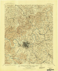
~ Greenbrier TN topo map, 1:125000 scale, 30 X 30 Minute, Historical, 1903, updated 1945
Greenbrier, Tennessee, USGS topographic map dated 1903.
Includes geographic coordinates (latitude and longitude). This topographic map is suitable for hiking, camping, and exploring, or framing it as a wall map.
Printed on-demand using high resolution imagery, on heavy weight and acid free paper, or alternatively on a variety of synthetic materials.
Topos available on paper, Waterproof, Poly, or Tyvek. Usually shipping rolled, unless combined with other folded maps in one order.
- Product Number: USGS-5338966
- Free digital map download (high-resolution, GeoPDF): Greenbrier, Tennessee (file size: 9 MB)
- Map Size: please refer to the dimensions of the GeoPDF map above
- Weight (paper map): ca. 55 grams
- Map Type: POD USGS Topographic Map
- Map Series: HTMC
- Map Verison: Historical
- Cell ID: 65604
- Scan ID: 149810
- Imprint Year: 1945
- Survey Year: 1901
- Datum: Unstated
- Map Projection: Polyconic
- Map published by United States Geological Survey
- Map Language: English
- Scanner Resolution: 600 dpi
- Map Cell Name: Greenbrier
- Grid size: 30 X 30 Minute
- Date on map: 1903
- Map Scale: 1:125000
- Geographical region: Tennessee, United States
Neighboring Maps:
All neighboring USGS topo maps are available for sale online at a variety of scales.
Spatial coverage:
Topo map Greenbrier, Tennessee, covers the geographical area associated the following places:
- Hygeia Springs - Joelton - Springmont - Oakwood Terrace - Cambridge Hills - Whispering Hills - Brentwood Park - Greenlawn - Barclay Square - Crunk - Brentwood - Antioch - Owen Estates - Flewellyn - Tate (historical) - Oak Hampton - Belle Rive - Union Hill - Jimtown (historical) - Glendale Park - Bethlehem - Oglesby - Tusculum - Centralville (historical) - North Hills Estates - Hite (historical) - Kimbro - Castlegate Estates - Tennessee Towne (historical) - Beachville (historical) - Doziers (historical) - Lakewood - Lickton - Watkins (historical) - Hermitage Hills - Rosewood - In-A-Vale-Estates - Cherry Hills - Clearview - Curtiswood - Pasquo - Chestnut Orchard - Donelson - Brooklin - Highland Heights - Crieve Hall - Hunters Store - Maple Row Estates - Woodbine - Harpeth Estates - Twin Valley - Solitude Acres - Hermitage Woods - White House - Glover Crossroad - Courtland - Georgemere - Red Bud - Walnut Hills - Bluegrass Meadows - Four Corners (historical) - Lincoya Hills - Marvel (historical) - Dunkled Estates - Rosebank - Forest of Brentwood - Dalemere - Bordeaux - Delray Park Estates - Rayon City - Brooklyn Heights - Tyree Springs (historical) - Murray Estates - Dekemont Downs - West Meade - Monticello - Forest Hills - Woodlake - Goodlettsville - Haysboro - Rolling Acres - White Hill - Gilroy (historical) - Glenview - Dry Fork (historical) - Richland - Langford Cove - Amqui - Old Hickory - East Point - Jordonia - Bellshire - Hillview - Providence - Sherwood Forest - Lohman - Hillwood - Metropolitan Government of Nashville-Davidson (balance) - Cottontown - Peaceful Acres
- Map Area ID: AREA36.536-87-86.5
- Northwest corner Lat/Long code: USGSNW36.5-87
- Northeast corner Lat/Long code: USGSNE36.5-86.5
- Southwest corner Lat/Long code: USGSSW36-87
- Southeast corner Lat/Long code: USGSSE36-86.5
- Northern map edge Latitude: 36.5
- Southern map edge Latitude: 36
- Western map edge Longitude: -87
- Eastern map edge Longitude: -86.5


