
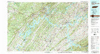
~ Watts Bar Lake TN topo map, 1:100000 scale, 30 X 60 Minute, Historical, 1981, updated 1984
Watts Bar Lake, Tennessee, USGS topographic map dated 1981.
Includes geographic coordinates (latitude and longitude). This topographic map is suitable for hiking, camping, and exploring, or framing it as a wall map.
Printed on-demand using high resolution imagery, on heavy weight and acid free paper, or alternatively on a variety of synthetic materials.
Topos available on paper, Waterproof, Poly, or Tyvek. Usually shipping rolled, unless combined with other folded maps in one order.
- Product Number: USGS-5338896
- Free digital map download (high-resolution, GeoPDF): Watts Bar Lake, Tennessee (file size: 30 MB)
- Map Size: please refer to the dimensions of the GeoPDF map above
- Weight (paper map): ca. 55 grams
- Map Type: POD USGS Topographic Map
- Map Series: HTMC
- Map Verison: Historical
- Cell ID: 68556
- Scan ID: 153428
- Imprint Year: 1984
- Woodland Tint: Yes
- Visual Version Number: 2
- Aerial Photo Year: 1981
- Edit Year: 1981
- Datum: NAD27
- Map Projection: Universal Transverse Mercator
- Map published by Tennessee Valley Authority
- Map Language: English
- Scanner Resolution: 600 dpi
- Map Cell Name: Watts Bar Lake
- Grid size: 30 X 60 Minute
- Date on map: 1981
- Map Scale: 1:100000
- Geographical region: Tennessee, United States
Neighboring Maps:
All neighboring USGS topo maps are available for sale online at a variety of scales.
Spatial coverage:
Topo map Watts Bar Lake, Tennessee, covers the geographical area associated the following places:
- Paint Rock Farm Lake Estates - Rambling Acres - Forest Heights - Holiday Shores - Lakewood - New Midway - Cedar Grove - Eaton Crossroads - Selkirk (historical) - Alnwick - Bonneville Estates - Chapman Grove - Centersville - Cannon Subdivision - Karns Mobile Home Kort - Highland Forest - Dogwood - South Hills - Jewett - Union Grove - Waterhaven - West Hills - Byrd Chapel - Morrisgap (historical) - Kingston - Martel Estates - Fairview - Rockwood - Lovell Heights - Fort Loudon Estates - Pawpaw Plains - Pine Grove - Kingston Heights - Eureka - King Arthur Court - Barton Mill - Balta - Ipe (historical) - Roddy - Oak Hills - Parkview - Ridgedale - Ten Mile - Akeman Crossroad - Lakeside - McMullens - Echo Valley - Station West - Tuskeegee (historical) - Solway - Chilhowee - Poplar Springs - Mount Zion - Robinson Crossroads - Windsor Park - Friendsville - Fair Oaks - Halfway Town (historical) - Pine Grove Estates - Tabor (historical) - Edgewater Estates - Ewing (historical) - Vonore - Green Valley - Jonesville - Concord Trailer Park - Kincaid - Westshore Estates - Dogwood Heights - Kiser - Wellsville - Lanier - Bucktown - Hopewell Mill - Phillips - Kingston Hills - Fairway Estates - Lovell Road Mobile Home Park - Busselltown - Plum Creek - Fagin - Christy Hill - Lake Shadow - Iron Divide (historical) - Blue Gem - Kingsgate - Slabtown - Peninsular Estates - Citico (historical) - Green Valley - College Grove - Orchard Valley Estates - Bradbury - Trails West - Twin Oaks - Idle Oaks - Cusick - Lawnville Meadows - Bayside - Bella Mara Estates
- Map Area ID: AREA3635.5-85-84
- Northwest corner Lat/Long code: USGSNW36-85
- Northeast corner Lat/Long code: USGSNE36-84
- Southwest corner Lat/Long code: USGSSW35.5-85
- Southeast corner Lat/Long code: USGSSE35.5-84
- Northern map edge Latitude: 36
- Southern map edge Latitude: 35.5
- Western map edge Longitude: -85
- Eastern map edge Longitude: -84


