
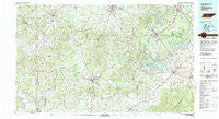
~ Tullahoma TN topo map, 1:100000 scale, 30 X 60 Minute, Historical, 1981, updated 1982
Tullahoma, Tennessee, USGS topographic map dated 1981.
Includes geographic coordinates (latitude and longitude). This topographic map is suitable for hiking, camping, and exploring, or framing it as a wall map.
Printed on-demand using high resolution imagery, on heavy weight and acid free paper, or alternatively on a variety of synthetic materials.
Topos available on paper, Waterproof, Poly, or Tyvek. Usually shipping rolled, unless combined with other folded maps in one order.
- Product Number: USGS-5338892
- Free digital map download (high-resolution, GeoPDF): Tullahoma, Tennessee (file size: 26 MB)
- Map Size: please refer to the dimensions of the GeoPDF map above
- Weight (paper map): ca. 55 grams
- Map Type: POD USGS Topographic Map
- Map Series: HTMC
- Map Verison: Historical
- Cell ID: 68491
- Scan ID: 153426
- Imprint Year: 1982
- Woodland Tint: Yes
- Aerial Photo Year: 1979
- Edit Year: 1981
- Datum: NAD27
- Map Projection: Universal Transverse Mercator
- Map published by United States Geological Survey
- Map published by Tennessee Valley Authority
- Map Language: English
- Scanner Resolution: 600 dpi
- Map Cell Name: Tullahoma
- Grid size: 30 X 60 Minute
- Date on map: 1981
- Map Scale: 1:100000
- Geographical region: Tennessee, United States
Neighboring Maps:
All neighboring USGS topo maps are available for sale online at a variety of scales.
Spatial coverage:
Topo map Tullahoma, Tennessee, covers the geographical area associated the following places:
- Winchester Springs - Krapp Spring - Smithland - Sevenmile Hill - Singleton - Fairview - Countyline - Prospect - Broadview - Rutledge Falls - Blue Creek - White Oak Trailer Park - Turkey Creek - Egam - Blakeville - Decherd - Glenview - Crystal Springs - Greenwood Estates - Bruner Crossing - Woodrow - Bel-Aire - Pleasant Grove - Mountain View Acres - Eastwood Estates - Forest Hills - Yukon - Taylor Creek East Subdivision - Ostella - Melrose Park - Belleville - Hawthorne - Dripping Springs Subdivision - Bugscuffle - Frankewing - Beans Creek - Delina - Sulphur Springs - Bunker Hill - Three Forks - Liberty - Westside Heights - Manchester - Calls - Southgate Park - Browns Shop - Molino - Himesville - Hickory Hill Estates - Bottle Hollow - New Herman - Fayetteville - Campbells Station - Wells Hill (historical) - Dry Creek Estates - Bobs Cross Roads (historical) - Cortner - Millville - Ebenezer - Merrit Mobile Village - Taylor Creek West Subdivision - Mayberry Courts - Elkton - Boonshill - Belleview - Kirkland - Hamilton Mill - Keith Springs - Sycamore Swamp - Westbrook - Tarpley - Awalt (historical) - Brownington - Dickson Town - Creekwood - Wallace Acres - Highland Rim - Richland (historical) - Woodlawn Subdivision - Richmond - Westwood Homes - Bakertown - Lexie - Kissling Crossing - Vanntown - Coldwater - Belvidere - Sumac - Aymett Town - Murray Lake Estates - Brick Church - Lois - Tara Estates - Five Points - Branchville - Taylortown - Pleasant Grove Subdivision - Southgate Subdivision - Dellrose - Blanche
- Map Area ID: AREA35.535-87-86
- Northwest corner Lat/Long code: USGSNW35.5-87
- Northeast corner Lat/Long code: USGSNE35.5-86
- Southwest corner Lat/Long code: USGSSW35-87
- Southeast corner Lat/Long code: USGSSE35-86
- Northern map edge Latitude: 35.5
- Southern map edge Latitude: 35
- Western map edge Longitude: -87
- Eastern map edge Longitude: -86


