
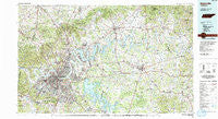
~ Nashville TN topo map, 1:100000 scale, 30 X 60 Minute, Historical, 1984, updated 1985
Nashville, Tennessee, USGS topographic map dated 1984.
Includes geographic coordinates (latitude and longitude). This topographic map is suitable for hiking, camping, and exploring, or framing it as a wall map.
Printed on-demand using high resolution imagery, on heavy weight and acid free paper, or alternatively on a variety of synthetic materials.
Topos available on paper, Waterproof, Poly, or Tyvek. Usually shipping rolled, unless combined with other folded maps in one order.
- Product Number: USGS-5338882
- Free digital map download (high-resolution, GeoPDF): Nashville, Tennessee (file size: 29 MB)
- Map Size: please refer to the dimensions of the GeoPDF map above
- Weight (paper map): ca. 55 grams
- Map Type: POD USGS Topographic Map
- Map Series: HTMC
- Map Verison: Historical
- Cell ID: 68028
- Scan ID: 148609
- Imprint Year: 1985
- Woodland Tint: Yes
- Aerial Photo Year: 1981
- Edit Year: 1984
- Datum: NAD27
- Map Projection: Universal Transverse Mercator
- Map published by Tennessee Valley Authority
- Map Language: English
- Scanner Resolution: 600 dpi
- Map Cell Name: Nashville
- Grid size: 30 X 60 Minute
- Date on map: 1984
- Map Scale: 1:100000
- Geographical region: Tennessee, United States
Neighboring Maps:
All neighboring USGS topo maps are available for sale online at a variety of scales.
Spatial coverage:
Topo map Nashville, Tennessee, covers the geographical area associated the following places:
- Curtiswood - Pinnacle - Beech Bottom - Flat Rock - Huntington Ridge Estates - Cambridge Hills - Mount Carmel (historical) - Grassland Estates - Heathrow - Town Park Estates - Brooklin - Gilroy (historical) - Fountainhead - Rural Hill - Inglewood - Hickory Valley Estates - Rolling Acres - Ivy Point - Berryville - Big Spring (historical) - Hygeia Springs - Providence - Tate (historical) - Wrencoe - Sherrilltown - Creekmont - Dekemont Downs - Tuckers Gap (historical) - Alexandria - Stones River Homes - Ocana - Hillview Estates - Oakvale - Templow - Glenview - Una - Pennville (historical) - Rock City - Raintree Forest - White Hill - Vaughns Gap - Cloverhill - Green Hills - Tennessee Towne (historical) - Taylorsville - Tusculum - Lebanon - Greenlawn - Maplewood - Jefferson Springs - Caravelle - Shackle Island - Laguardo - Mount View - Commerce - Delray Park Estates - Red Bud - North Hills Estates - Dixon (historical) - Brooklyn Heights - Brookview Estates - Beverly Heights - Antioch - Muncie (historical) - Berry Hill - Oak Hill - Metropolitan Government of Nashville-Davidson (balance) - Centralville (historical) - Kimbro - Brush Creek - Glendale Park - Joelton - Northcreek Commons - Meadowvale - Edge-O-Lake Estates - Shaver Town - Meadorville - Mount Juliet - Monticello - Tulip Grove - Mims (historical) - Watertown - Old Bethpage - Pointed Side Acres - Bairds Mill - Courtland - Coopertown - Bethany Hills - Woodbine - Hartsville - Fair Oaks - South Tunnel - Grant - Mount Zion - Paragon Mills - Montague - Beech Hill - Rocky Creek Subdivision - Bakers - Weir (historical)
- Map Area ID: AREA36.536-87-86
- Northwest corner Lat/Long code: USGSNW36.5-87
- Northeast corner Lat/Long code: USGSNE36.5-86
- Southwest corner Lat/Long code: USGSSW36-87
- Southeast corner Lat/Long code: USGSSE36-86
- Northern map edge Latitude: 36.5
- Southern map edge Latitude: 36
- Western map edge Longitude: -87
- Eastern map edge Longitude: -86


