
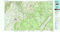
~ Mc Minnville TN topo map, 1:100000 scale, 30 X 60 Minute, Historical, 1981, updated 1981
Mc Minnville, Tennessee, USGS topographic map dated 1981.
Includes geographic coordinates (latitude and longitude). This topographic map is suitable for hiking, camping, and exploring, or framing it as a wall map.
Printed on-demand using high resolution imagery, on heavy weight and acid free paper, or alternatively on a variety of synthetic materials.
Topos available on paper, Waterproof, Poly, or Tyvek. Usually shipping rolled, unless combined with other folded maps in one order.
- Product Number: USGS-5338858
- Free digital map download (high-resolution, GeoPDF): Mc Minnville, Tennessee (file size: 28 MB)
- Map Size: please refer to the dimensions of the GeoPDF map above
- Weight (paper map): ca. 55 grams
- Map Type: POD USGS Topographic Map
- Map Series: HTMC
- Map Verison: Historical
- Cell ID: 67931
- Scan ID: 150202
- Imprint Year: 1981
- Woodland Tint: Yes
- Aerial Photo Year: 1976
- Edit Year: 1981
- Datum: NAD27
- Map Projection: Universal Transverse Mercator
- Map published by United States Geological Survey
- Map published by Tennessee Valley Authority
- Map Language: English
- Scanner Resolution: 600 dpi
- Map Cell Name: McMinnville
- Grid size: 30 X 60 Minute
- Date on map: 1981
- Map Scale: 1:100000
- Geographical region: Tennessee, United States
Neighboring Maps:
All neighboring USGS topo maps are available for sale online at a variety of scales.
Spatial coverage:
Topo map Mc Minnville, Tennessee, covers the geographical area associated the following places:
- Claysville - Chestnut Grove - Lanatana Estates - Catlen - Kiowa Subdivision - Perilla (historical) - Chalybeate - Volunteer Heights - Comanche Subdivision - Lonewood - Phillps Subdivision - Baker Crossroads - Young (historical) - Livesay - Leoni - White Oak Forest - Sainville - Rowland - Newton - Harmony - Big Lick - Woods - Obed River Estates - Camelot - Hillcrest - Greens Crossroad - Hilltop Acres - Old Winesap - Rainy (historical) - Ojibwa Subdivision - Lantana - Parkview - Heads (historical) - Bon Air - Vandever - Hillis (historical) - Mount Pisgah - Bethany - Brookhaven - Mount Vernon Estates - Sparta Hills - Winesap - Eastland - Liberty Hill - Doyle - Shady Grove - Gerren Heights - Nicholson Springs (historical) - Shiloh - Morgan Springs - Lusk - Daylight - Dibrell - Sparta Heights - New Era - Dill - Smith Chapel - Hiawassee - Cold Spring - Watkins - Bryan Mill - Paine Spring - Pleasant View - Cumberland Heights - Heritage Estates - Sligo (historical) - Gum Spring - Taylors Chapel - Brockdell - Oakdale - Dunrovin Estates - Sunset Terrace - Meade (historical) - Browntown - Mount Ararat - Tanbark (historical) - South Hills - Sherwood Farm - River Hill - Morrison - Sugar Tree Knob - Midway - Thomas Springs - Dodson - Woodstock Estates - Rabbit Bluff (historical) - Fanchers Mills - Woodlawn - Hale - Jan Mor Acres - Stewart Chapel - Evanston (historical) - Crossville Estates - Jefferson - Ravenscroft - Cranmore Cove - Grapevine (historical) - Blue Hill - Ridgedale - Burke
- Map Area ID: AREA3635.5-86-85
- Northwest corner Lat/Long code: USGSNW36-86
- Northeast corner Lat/Long code: USGSNE36-85
- Southwest corner Lat/Long code: USGSSW35.5-86
- Southeast corner Lat/Long code: USGSSE35.5-85
- Northern map edge Latitude: 36
- Southern map edge Latitude: 35.5
- Western map edge Longitude: -86
- Eastern map edge Longitude: -85


