
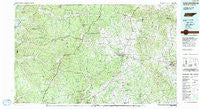
~ Lawrenceburg TN topo map, 1:100000 scale, 30 X 60 Minute, Historical, 1985, updated 1991
Lawrenceburg, Tennessee, USGS topographic map dated 1985.
Includes geographic coordinates (latitude and longitude). This topographic map is suitable for hiking, camping, and exploring, or framing it as a wall map.
Printed on-demand using high resolution imagery, on heavy weight and acid free paper, or alternatively on a variety of synthetic materials.
Topos available on paper, Waterproof, Poly, or Tyvek. Usually shipping rolled, unless combined with other folded maps in one order.
- Product Number: USGS-5338856
- Free digital map download (high-resolution, GeoPDF): Lawrenceburg, Tennessee (file size: 27 MB)
- Map Size: please refer to the dimensions of the GeoPDF map above
- Weight (paper map): ca. 55 grams
- Map Type: POD USGS Topographic Map
- Map Series: HTMC
- Map Verison: Historical
- Cell ID: 67830
- Scan ID: 144015
- Imprint Year: 1991
- Woodland Tint: Yes
- Aerial Photo Year: 1981
- Edit Year: 1985
- Datum: NAD27
- Map Projection: Universal Transverse Mercator
- Map published by Tennessee Valley Authority
- Map Language: English
- Scanner Resolution: 600 dpi
- Map Cell Name: Lawrenceburg
- Grid size: 30 X 60 Minute
- Date on map: 1985
- Map Scale: 1:100000
- Geographical region: Tennessee, United States
Neighboring Maps:
All neighboring USGS topo maps are available for sale online at a variety of scales.
Spatial coverage:
Topo map Lawrenceburg, Tennessee, covers the geographical area associated the following places:
- Allens Creek (historical) - Upper Holly Creek - Lutts - Gum Springs - Rebel Acres - Star (historical) - Victory (historical) - Brier Hill - Sexton - Mars Hill - Oak Hill - Mount Hope - Flatwoods - Bethlehem - Leatherwood - Strathmore (historical) - Nancy (historical) - Deerfield - Sandy Hook - Napier - Lower Holly Creek - Alexander Springs - Clifton - Kitchens - Lower Mockeson - New Haven - Rossboro - Stiversville - Webber City - Oak Grove - Loretto - Providence - Houston - Turkey Track - Gandy - Scotts Mill - Ramah - Campbellsville - Revilo - Henryville - Antioch - Gipsonville - Lodi - Upper Mockeson - Harwell - Lindauer (historical) - Summertown - Jonestown - Sweetwater - Green River (historical) - Five Points - Starkey (historical) - Leoma - Yokley - Clearview Heights - Mooney - Fall River - Pinkney - Highland - Waynesboro - Shady Grove (historical) - Springers Station - Lancelot Acres - Cypress Inn - Gaitherville - Lesters - McGlamery Stand - Clifton Junction - Pleasant Valley - Hickory Heights - Brown Crossroads - Rockquarry (historical) - Hardwick (historical) - Pea Ridge - Union Hill - Collinwood - Fairview - Crossroads - Buffalo Valley - Kedron - Browntown (historical) - Bird Mill - Topsy - Geneva - Sorby (historical) - Screamer - Glendale Estates - Flat Woods - Rockdale - Corning (historical) - Anthony Hill - Crewstown - Lawrenceburg - Broadview - Wolf Creek - Lovie (historical) - Yates (historical) - Longview Subdivision - Rascal Town - Carpenters (historical)
- Map Area ID: AREA35.535-88-87
- Northwest corner Lat/Long code: USGSNW35.5-88
- Northeast corner Lat/Long code: USGSNE35.5-87
- Southwest corner Lat/Long code: USGSSW35-88
- Southeast corner Lat/Long code: USGSSE35-87
- Northern map edge Latitude: 35.5
- Southern map edge Latitude: 35
- Western map edge Longitude: -88
- Eastern map edge Longitude: -87


